Weather Alerts for Alaska
1. Flood Warning for: South Slopes Of The Central Brooks Range
2. Flood Watch for: Kuskokwim Valley West; Kuskokwim Valley East; Interior Kuskokwim Delta; Northern Bristol Bay Coast; Inland Bristol Bay
3. Flood Watch for: South Slopes Of The Central Brooks Range; South Slopes of the Western Brooks Range; Upper Kobuk Valleys
4. Flood Watch for: Southern Seward Peninsula Coast; Interior Seward Peninsula; Eastern Norton Sound and Nulato Hills
5. Flood Watch for: Western Capes
6. Hydrologic Outlook for: Howard Pass and the Delong Mountains; Central Brooks Range; Noatak Valley; Lower Kobuk Valley; Northern Seward Peninsula; Lower Yukon River; Lower Koyukuk Valley; Middle Yukon Valley; Lower Yukon and Innoko Valleys; Upper Koyukuk Valley; Dalton Highway Summits; Central Interior
7. Hydrologic Outlook for: Howard Pass and the Delong Mountains; Central Brooks Range; Noatak Valley; Lower Kobuk Valley; Northern Seward Peninsula; Southern Seward Peninsula Coast; Interior Seward Peninsula; Eastern Norton Sound and Nulato Hills; Lower Yukon River; Lower Koyukuk Valley; Middle Yukon Valley; Lower Yukon and Innoko Valleys; Upper Koyukuk Valley; Dalton Highway Summits; Central Interior
8. Hydrologic Outlook for: Howard Pass and the Delong Mountains; Central Brooks Range; South Slopes Of The Central Brooks Range; South Slopes of the Western Brooks Range; Noatak Valley; Lower Kobuk Valley; Northern Seward Peninsula; Upper Kobuk Valleys; Southern Seward Peninsula Coast; Interior Seward Peninsula; Eastern Norton Sound and Nulato Hills; Lower Yukon River; Lower Koyukuk Valley; Middle Yukon Valley; Lower Yukon and Innoko Valleys; Upper Koyukuk Valley; Dalton Highway Summits; Central Interior
9. Hydrologic Outlook for: Kuskokwim Valley West; Kuskokwim Valley East; Interior Kuskokwim Delta; Western Capes; Northern Bristol Bay Coast; Inland Bristol Bay
10. Hydrologic Outlook for: White Mountains and High Terrain South of the Yukon River; Upper Chena River Valley; Tanana Flats; Eielson AFB and Salcha; Goldstream Valley and Nenana Hills; Chatanika River Valley; Two Rivers; Fairbanks Metro Area; Nenana
11. Special Weather Statement for: Bristol Bay Borough (Naknek and King Salmon); Lake Iliamna / Nila Vena / Nanvarpak
12. Special Weather Statement for: Bristol Bay Borough (Naknek and King Salmon); Lake Iliamna / Nila Vena / Nanvarpak
13. Wind Advisory for: Eastern Alaska Range North of Trims Camp
14. Wind Advisory for: Northern Denali Borough
15. Winter Storm Warning for: Central Arctic Plains; Central Brooks Range
16. Winter Weather Advisory for: Central Beaufort Sea Coast
Want more detail? Get the Complete 7 Day and Night Detailed Forecast!
Current U.S. National Radar--Current
The Current National Weather Radar is shown below with a UTC Time (subtract 5 hours from UTC to get Eastern Time).

National Weather Forecast--Current
The Current National Weather Forecast and National Weather Map are shown below.

National Weather Forecast for Tomorrow
Tomorrow National Weather Forecast and Tomorrow National Weather Map are show below.

North America Water Vapor (Moisture)
This map shows recent moisture content over North America. Bright and colored areas show high moisture (ie, clouds); brown indicates very little moisture present; black indicates no moisture.

Weather Topic: What are Shelf Clouds?
Home - Education - Cloud Types - Shelf Clouds
 Next Topic: Sleet
A shelf cloud is similar to a wall cloud, but forms at the front
of a storm cloud, instead of at the rear, where wall clouds form.
A shelf cloud is caused by a series of events set into motion by the advancing
storm; first, cool air settles along the ground where precipitation has just fallen.
As the cool air is brought in, the warmer air is displaced, and rises above it,
because it is less dense. When the warmer air reaches the bottom of the storm cloud,
it begins to cool again, and the resulting condensation is a visible shelf cloud.
Next Topic: Sleet
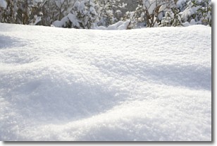
Weather Topic: What is Snow?
Home - Education - Precipitation - Snow
 Next Topic: Stratocumulus Clouds
Snow is precipitation taking the form of ice crystals. Each ice crystal, or snowflake,
has unique characteristics, but all of them grow in a hexagonal structure.
Snowfall can last for sustained periods of time and result in significant buildup
of snow on the ground.
On the earth's surface, snow starts out light and powdery, but as it begins to melt
it tends to become more granular, producing small bits of ice which have the consistency of
sand. After several cycles of melting and freezing, snow can become very dense
and ice-like, commonly known as snow pack.
Next Topic: Stratocumulus Clouds
Current conditions powered by WeatherAPI.com


