Weather Alerts for Idaho
1. Air Quality Alert for: Clearwater, ID; Idaho, ID
2. Air Quality Alert for: Latah, ID; Lewis, ID; Nez Perce, ID
3. Air Quality Alert for: Lewis, ID; Nez Perce, ID
4. Air Quality Alert for: Orofino/Grangeville Region
5. Air Quality Alert for: Teton, ID
6. Extreme Heat Warning for: Lewiston Area; Lower Garfield and Asotin Counties; Moses Lake Area; Upper Columbia Basin; Wenatchee Area; Okanogan Valley; Waterville Plateau; Central Chelan County
7. Flash Flood Watch for: West Central Mountains; Lower Treasure Valley; Boise Mountains; Upper Treasure Valley; Southwest Highlands; Western Magic Valley; Camas Prairie; Owyhee Mountains; Southern Twin Falls County; Upper Weiser River; Harney County; Baker County; Malheur County; Oregon Lower Treasure Valley
8. Flood Watch for: Idaho, ID; Lemhi, ID
9. Flood Watch for: Sawtooth/Stanley Basin
10. Flood Watch for: Shoshone/Lava Beds; Arco/Mud Lake Desert; Upper Snake River Plain; Lower Snake River Plain; Eastern Magic Valley; Southern Hills/Albion Mountains; Raft River Region; Marsh and Arbon Highlands; Franklin/Eastern Oneida Region; Bear River Range; Bear Lake Valley; Blackfoot Mountains; Caribou Range; Big Hole Mountains; Teton Valley; Centennial Mountains/Island Park; Beaverhead/Lemhi Highlands; Lost River Valleys; Lost River Range; Challis/Pahsimeroi Valleys; Frank Church Wilderness; Sun Valley Region; Big Lost Highlands/Copper Basin; Wood River Foothills
11. Heat Advisory for: Coeur d'Alene Area; Idaho Palouse; Lewis and Southern Nez Perce Counties; Northeast Blue Mountains; Washington Palouse; Spokane Area; Northeast Mountains; Okanogan Highlands; Western Okanogan County
12. Hydrologic Outlook for: Clearwater, ID; Deer Lodge, MT; Granite, MT; Mineral, MT; Missoula, MT; Powell, MT; Silver Bow, MT
Want more detail? Get the Complete 7 Day and Night Detailed Forecast!
Current U.S. National Radar--Current
The Current National Weather Radar is shown below with a UTC Time (subtract 5 hours from UTC to get Eastern Time).

National Weather Forecast--Current
The Current National Weather Forecast and National Weather Map are shown below.

National Weather Forecast for Tomorrow
Tomorrow National Weather Forecast and Tomorrow National Weather Map are show below.

North America Water Vapor (Moisture)
This map shows recent moisture content over North America. Bright and colored areas show high moisture (ie, clouds); brown indicates very little moisture present; black indicates no moisture.

Weather Topic: What are Fractus Clouds?
Home - Education - Cloud Types - Fractus Clouds
 Next Topic: Freezing Rain
A fractus cloud (scud) is a fragmented, tattered cloud which has
likely been sheared off of another cloud. They are accessory clouds, meaning they
develop from parent clouds, and are named in a way which describes the original
cloud which contained them.
Fractus clouds which have originated from cumulus clouds are referred to as
cumulus fractus, while fractus clouds which have originated from stratus clouds
are referred to as stratus fractus. Under certain conditions a fractus cloud might
merge with another cloud, or develop into a cumulus cloud, but usually a
fractus cloud seen by itself will dissipate rapidly.
They are often observed on the leading and trailing edges of storm clouds,
and are a display of wind activity.
Next Topic: Freezing Rain
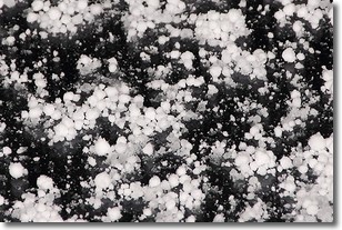
Weather Topic: What is Graupel?
Home - Education - Precipitation - Graupel
 Next Topic: Hail
Graupel is a form of precipitation that is created by atmospheric conditions
which cause supercooled water droplets to contact snow crystals and freeze to
their surface.
Sometimes known as soft hail or snow pellets, graupel is delicate and easily
destroyed by touch. Whereas hail usually falls during severe weather, graupel
doesn't require such conditions to form, and can form in mild precipitation
similar to situations which produce snowfall.
Next Topic: Hail
Current conditions powered by WeatherAPI.com


