Weather Alerts for California
1. Air Quality Alert for: Imperial County Southwest; Imperial County West; Imperial Valley
2. High Wind Warning for: Death Valley National Park
3. Lake Wind Advisory for: Lassen-Eastern Plumas-Eastern Sierra Counties; Greater Lake Tahoe Area; Mono; Greater Lake Tahoe Area
4. Wind Advisory for: Apple and Lucerne Valleys; San Diego County Deserts
5. Wind Advisory for: Central Siskiyou County
6. Wind Advisory for: Eastern Sierra Slopes of Inyo County; White Mountains of Inyo County; Owens Valley South; Owens Valley North; Lincoln County
7. Wind Advisory for: Imperial County Southwest
8. Wind Advisory for: Riverside County Mountains; San Diego County Mountains
9. Wind Advisory for: San Bernardino County Mountains
10. Wind Advisory for: San Gorgonio Pass Near Banning
11. Winter Storm Warning for: Lassen Volcanic National Park; Sierra Nevada of Tehama-Butte-Plumas Counties Above 3000 ft; Sierra Nevada of Sierra-Nevada-Placer Counties Above 5000 ft Including Interstate 80; Sierra Nevada of El Dorado-Amador-Northern Alpine Counties Above 5000 ft Including Highway 50; Sierra Nevada of Calaveras-Tuolumne-Southern Alpine Counties Above 5000 ft
12. Winter Storm Warning for: Yosemite NP outside of the valley; Upper San Joaquin River; Kaiser to Rodgers Ridge; Kings Canyon NP; Sequoia NP
13. Winter Weather Advisory for: Greater Lake Tahoe Area; Greater Lake Tahoe Area
14. Winter Weather Advisory for: Mono
15. Winter Weather Advisory for: Northeastern Trinity
16. Winter Weather Advisory for: Western Siskiyou County; Central Siskiyou County; South Central Siskiyou County
Want more detail? Get the Complete 7 Day and Night Detailed Forecast!
Current U.S. National Radar--Current
The Current National Weather Radar is shown below with a UTC Time (subtract 5 hours from UTC to get Eastern Time).

National Weather Forecast--Current
The Current National Weather Forecast and National Weather Map are shown below.

National Weather Forecast for Tomorrow
Tomorrow National Weather Forecast and Tomorrow National Weather Map are show below.

North America Water Vapor (Moisture)
This map shows recent moisture content over North America. Bright and colored areas show high moisture (ie, clouds); brown indicates very little moisture present; black indicates no moisture.

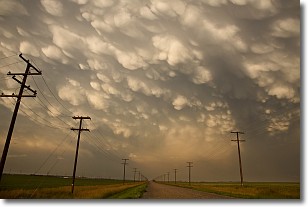
Weather Topic: What are Mammatus Clouds?
Home - Education - Cloud Types - Mammatus Clouds
 Next Topic: Nimbostratus Clouds
A mammatus cloud is a cloud with a unique feature which resembles
a web of pouches hanging along the base of the cloud.
In the United States, mammatus clouds tend to form in the warmer months, commonly
in the Midwest and eastern regions.
While they usually form at the bottom of a cumulonimbis cloud, they can also form
under altostratus, altocumulus, stratocumulus, and cirrus clouds. Mammatus clouds
warn that severe weather is close.
Next Topic: Nimbostratus Clouds
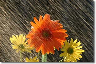
Weather Topic: What is Precipitation?
Home - Education - Precipitation - Precipitation
 Next Topic: Rain
Precipitation can refer to many different forms of water that
may fall from clouds. Precipitation occurs after a cloud has become saturated to
the point where its water particles are more dense than the air below the cloud.
In most cases, precipitation will reach the ground, but it is not uncommon for
precipitation to evaporate before it reaches the earth's surface.
When precipitation evaporates before it contacts the ground it is called Virga.
Graupel, hail, sleet, rain, drizzle, and snow are forms of precipitation, but fog
and mist are not considered precipitation because the water vapor which
constitutes them isn't dense enough to fall to the ground.
Next Topic: Rain
Current conditions powered by WeatherAPI.com


