Weather Alerts for California
1. Air Quality Alert for: Imperial County Southwest; Imperial County West; Imperial Valley
2. High Wind Warning for: Death Valley National Park
3. Wind Advisory for: Apple and Lucerne Valleys; San Diego County Deserts
4. Wind Advisory for: Eastern Sierra Slopes of Inyo County; White Mountains of Inyo County; Owens Valley South; Owens Valley North; Lincoln County
5. Wind Advisory for: Imperial County Southwest
6. Wind Advisory for: Indian Wells Valley; Mojave Desert
7. Wind Advisory for: Interstate 5 Corridor; Western San Gabriel Mountains and Highway 14 Corridor; Eastern San Gabriel Mountains; Western Antelope Valley Foothills; Eastern Antelope Valley Foothills; Antelope Valley
8. Wind Advisory for: Mojave Desert Slopes
9. Wind Advisory for: Riverside County Mountains; San Diego County Mountains
10. Wind Advisory for: San Bernardino County Mountains
11. Wind Advisory for: San Gorgonio Pass Near Banning
12. Winter Storm Warning for: Lassen Volcanic National Park; Sierra Nevada of Tehama-Butte-Plumas Counties Above 3000 ft; Sierra Nevada of Sierra-Nevada-Placer Counties Above 5000 ft Including Interstate 80; Sierra Nevada of El Dorado-Amador-Northern Alpine Counties Above 5000 ft Including Highway 50; Sierra Nevada of Calaveras-Tuolumne-Southern Alpine Counties Above 5000 ft
13. Winter Storm Warning for: Yosemite NP outside of the valley; Upper San Joaquin River; Kaiser to Rodgers Ridge; Kings Canyon NP; Sequoia NP
14. Winter Weather Advisory for: Greater Lake Tahoe Area; Greater Lake Tahoe Area
15. Winter Weather Advisory for: Mono
16. Winter Weather Advisory for: Northeastern Trinity
17. Winter Weather Advisory for: Western Siskiyou County; Central Siskiyou County; South Central Siskiyou County
Want more detail? Get the Complete 7 Day and Night Detailed Forecast!
Current U.S. National Radar--Current
The Current National Weather Radar is shown below with a UTC Time (subtract 5 hours from UTC to get Eastern Time).

National Weather Forecast--Current
The Current National Weather Forecast and National Weather Map are shown below.

National Weather Forecast for Tomorrow
Tomorrow National Weather Forecast and Tomorrow National Weather Map are show below.

North America Water Vapor (Moisture)
This map shows recent moisture content over North America. Bright and colored areas show high moisture (ie, clouds); brown indicates very little moisture present; black indicates no moisture.

Weather Topic: What are Cirrocumulus Clouds?
Home - Education - Cloud Types - Cirrocumulus Clouds
 Next Topic: Cirrostratus Clouds
Cirrocumulus clouds form at high altitudes (usually around 5 km)
and have distinguishing characteristics displayed in a fine layer of
small cloud patches. These small cloud patches are sometimes referred to as
"cloudlets" in relation to the whole cloud formation.
Cirrocumulus clouds are formed from ice crystals and water droplets. Often, the
water droplets in the cloud freeze into ice crystals and the cloud becomes a
cirrostratus cloud. Because of this common occurrence, cirrocumulus cloud
formations generally pass rapidly.
Next Topic: Cirrostratus Clouds
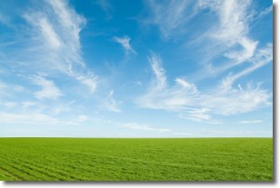
Weather Topic: What are Cirrus Clouds?
Home - Education - Cloud Types - Cirrus Clouds
 Next Topic: Condensation
Cirrus clouds are high-level clouds that occur above 20,000 feet
and are composed mainly of ice crystals.
They are thin and wispy in appearance.
What do they indicate?
They are often the first sign of an approaching storm.
Next Topic: Condensation
Current conditions powered by WeatherAPI.com


