Weather Alerts for California
Severe Thunderstorm Warning
1. Extreme Heat Warning for: Western Siskiyou County; Central Siskiyou County
2. Flash Flood Warning for: San Diego, CA
3. Flash Flood Warning for: San Diego, CA
4. Flood Advisory for: Fresno, CA
5. Flood Advisory for: Fresno, CA
6. Flood Advisory for: Kern, CA
7. Flood Advisory for: Kern, CA
8. Flood Advisory for: Madera, CA; Mariposa, CA
9. Flood Advisory for: Riverside, CA
10. Flood Advisory for: Riverside, CA
11. Flood Advisory for: San Diego, CA
12. Flood Advisory for: Sierra, CA
13. Flood Watch for: Lassen-Eastern Plumas-Eastern Sierra Counties; Greater Lake Tahoe Area; Mono; Mineral and Southern Lyon Counties; Greater Lake Tahoe Area; Greater Reno-Carson City-Minden Area
14. Flood Watch for: Yosemite NP outside of the valley; Yosemite Valley; San Joaquin River Canyon; Upper San Joaquin River; Kaiser to Rodgers Ridge; Kings Canyon NP; Grant Grove Area; Sequoia NP; South End of the Upper Sierra
15. Red Flag Warning for: Trinity
16. Red Flag Warning for: Western Klamath National Forest; Central Siskiyou County Including Shasta Valley; Shasta-Trinity National Forest in Siskiyou County; Siskiyou County from the Cascade Mountains East and South to Mt Shasta; Modoc County Except for the Surprise Valley; Umpqua National Forest; Western Rogue Basin including the Illinois Valley; Siskiyou Mountains; Eastern Rogue Valley; Southern Oregon Cascades; Klamath Basin and the Fremont-Winema National Forest; South Central Oregon Desert including the BLM Land in Eastern Lake and Western Harney Counties
17. Red Flag Warning for: Western Klamath National Forest; Central Siskiyou County Including Shasta Valley; Shasta-Trinity National Forest in Siskiyou County; Siskiyou County from the Cascade Mountains East and South to Mt Shasta; Modoc County Except for the Surprise Valley; Umpqua National Forest; Western Rogue Basin including the Illinois Valley; Siskiyou Mountains; Eastern Rogue Valley; Southern Oregon Cascades; Klamath Basin and the Fremont-Winema National Forest; South Central Oregon Desert including the BLM Land in Eastern Lake and Western Harney Counties
18. Severe Thunderstorm Warning for: Imperial, CA
19. Severe Thunderstorm Warning for: Imperial, CA
20. Severe Thunderstorm Warning for: Riverside, CA
21. Severe Thunderstorm Warning for: San Diego, CA
22. Special Weather Statement for: Greater Lake Tahoe Area
23. Special Weather Statement for: Kaiser to Rodgers Ridge; Kings Canyon NP
24. Special Weather Statement for: Lassen-Eastern Plumas-Eastern Sierra Counties
25. Special Weather Statement for: San Bernardino and Riverside County Valleys-The Inland Empire; San Bernardino County Mountains; Riverside County Mountains; Coachella Valley; San Gorgonio Pass Near Banning
26. Special Weather Statement for: Southern Trinity
27. Special Weather Statement for: West Slope Northern Sierra Nevada
28. Special Weather Statement for: Western San Gabriel Mountains and Highway 14 Corridor; Eastern San Gabriel Mountains; Western Antelope Valley Foothills; Eastern Antelope Valley Foothills; Antelope Valley
29. Special Weather Statement for: Yosemite NP outside of the valley
Want more detail? Get the Complete 7 Day and Night Detailed Forecast!
Current U.S. National Radar--Current
The Current National Weather Radar is shown below with a UTC Time (subtract 5 hours from UTC to get Eastern Time).

National Weather Forecast--Current
The Current National Weather Forecast and National Weather Map are shown below.

National Weather Forecast for Tomorrow
Tomorrow National Weather Forecast and Tomorrow National Weather Map are show below.

North America Water Vapor (Moisture)
This map shows recent moisture content over North America. Bright and colored areas show high moisture (ie, clouds); brown indicates very little moisture present; black indicates no moisture.

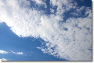
Weather Topic: What are Stratus Clouds?
Home - Education - Cloud Types - Stratus Clouds
 Next Topic: Wall Clouds
Stratus clouds are similar to altostratus clouds, but form at a
lower altitude and are identified by their fog-like appearance, lacking the
distinguishing features of most clouds.
Stratus clouds are wider than most clouds, and their base has a smooth, uniform
look which is lighter in color than a nimbostratus cloud.
The presence of a stratus cloud indicates the possibility of minor precipitation,
such as drizzle, but heavier precipitation does not typically arrive in the form
of a stratus cloud.
Next Topic: Wall Clouds
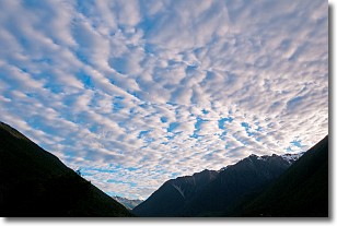
Weather Topic: What are Altocumulus Clouds?
Home - Education - Cloud Types - Altocumulus Clouds
 Next Topic: Altostratus Clouds
Similar to cirrocumulus clouds, altocumulus clouds are
characterized by cloud patches. They are distinguished by larger cloudlets
than cirrocumulus clouds but are still smaller than stratocumulus clouds.
Altocumulus clouds most commonly form in middle altitudes (between 2 and 5 km)
and may resemble, at times, the shape of a flying saucer.
These uncommon formations, called altocumulus lenticularis, are created by uplift
in the atmosphere and are most often seen in close proximity to mountains.
Next Topic: Altostratus Clouds
Current conditions powered by WeatherAPI.com


