Weather Alerts for California
1. Extreme Heat Warning for: Western Siskiyou County; Central Siskiyou County
2. Flash Flood Warning for: Imperial, CA
3. Flash Flood Warning for: Imperial, CA
4. Flash Flood Warning for: Imperial, CA
5. Flash Flood Warning for: Imperial, CA
6. Flash Flood Warning for: Inyo, CA; San Bernardino, CA
7. Flash Flood Warning for: Riverside, CA; San Bernardino, CA
8. Flash Flood Warning for: San Bernardino, CA
9. Flood Advisory for: Fresno, CA
10. Flood Advisory for: Fresno, CA
11. Flood Advisory for: Imperial, CA
12. Flood Advisory for: Los Angeles, CA
13. Flood Advisory for: Nevada, CA; Placer, CA; Sierra, CA
14. Flood Advisory for: Trinity, CA
15. Flood Advisory for: Trinity, CA
16. Flood Watch for: Lassen-Eastern Plumas-Eastern Sierra Counties; Greater Lake Tahoe Area; Mono; Mineral and Southern Lyon Counties; Greater Lake Tahoe Area; Greater Reno-Carson City-Minden Area
17. Flood Watch for: Yosemite NP outside of the valley; Yosemite Valley; San Joaquin River Canyon; Upper San Joaquin River; Kaiser to Rodgers Ridge; Kings Canyon NP; Grant Grove Area; Sequoia NP; South End of the Upper Sierra
18. Red Flag Warning for: Trinity
19. Red Flag Warning for: Western Klamath National Forest; Central Siskiyou County Including Shasta Valley; Shasta-Trinity National Forest in Siskiyou County; Siskiyou County from the Cascade Mountains East and South to Mt Shasta; Modoc County Except for the Surprise Valley; Umpqua National Forest; Western Rogue Basin including the Illinois Valley; Siskiyou Mountains; Eastern Rogue Valley; Southern Oregon Cascades; Klamath Basin and the Fremont-Winema National Forest; South Central Oregon Desert including the BLM Land in Eastern Lake and Western Harney Counties
20. Red Flag Warning for: Western Klamath National Forest; Central Siskiyou County Including Shasta Valley; Shasta-Trinity National Forest in Siskiyou County; Siskiyou County from the Cascade Mountains East and South to Mt Shasta; Modoc County Except for the Surprise Valley; Umpqua National Forest; Western Rogue Basin including the Illinois Valley; Siskiyou Mountains; Eastern Rogue Valley; Southern Oregon Cascades; Klamath Basin and the Fremont-Winema National Forest; South Central Oregon Desert including the BLM Land in Eastern Lake and Western Harney Counties
21. Special Weather Statement for: Fresno-Tulare Foothills; Fresno-Tulare Lower Sierra; Kaiser to Rodgers Ridge; Grant Grove Area
22. Special Weather Statement for: Mariposa Madera Foothills; Mariposa-Madera Lower Sierra; Yosemite NP outside of the valley; Yosemite Valley
23. Special Weather Statement for: Northern Sacramento Valley; Northeast Foothills/Sacramento Valley; Western Plumas County/Lassen Park
24. Special Weather Statement for: Western Siskiyou County
Want more detail? Get the Complete 7 Day and Night Detailed Forecast!
Current U.S. National Radar--Current
The Current National Weather Radar is shown below with a UTC Time (subtract 5 hours from UTC to get Eastern Time).

National Weather Forecast--Current
The Current National Weather Forecast and National Weather Map are shown below.

National Weather Forecast for Tomorrow
Tomorrow National Weather Forecast and Tomorrow National Weather Map are show below.

North America Water Vapor (Moisture)
This map shows recent moisture content over North America. Bright and colored areas show high moisture (ie, clouds); brown indicates very little moisture present; black indicates no moisture.

Weather Topic: What is Condensation?
Home - Education - Precipitation - Condensation
 Next Topic: Contrails
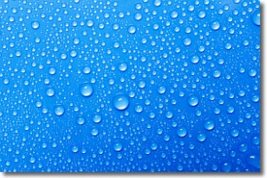
Condensation is the process which creates clouds, and therefore
it is a crucial process in the water cycle.
Condensation is the change of matter from a state of gas into a state of liquid,
and it happens because water molecules release heat into the atmosphere and
become organized into a more closely packed structure, what we might see as
water droplets.
Water is always present in the air around us as a vapor, but it's too small for
us to see. When water undergoes the process of condensation it becomes organized
into visible water droplets. You've probably seen condensation happen before on the
surface of a cold drink!
Next Topic: Contrails
Weather Topic: What are Cumulonimbus Clouds?
Home - Education - Cloud Types - Cumulonimbus Clouds
 Next Topic: Cumulus Clouds
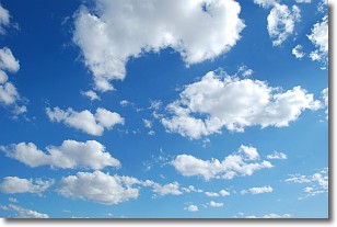
The final form taken by a growing cumulus cloud is the
cumulonimbus cloud, which is very tall and dense.
The tower of a cumulonimbus cloud can soar 23 km into the atmosphere, although
most commonly they stop growing at an altitude of 6 km.
Even small cumulonimbus clouds appear very large in comparison to other cloud types.
They can signal the approach of stormy weather, such as thunderstorms or blizzards.
Next Topic: Cumulus Clouds
Current conditions powered by WeatherAPI.com


