Weather Alerts for California
1. High Surf Advisory for: Catalina and Santa Barbara Islands; Ventura County Beaches; Malibu Coast; Los Angeles County Beaches
2. High Surf Advisory for: San Luis Obispo County Beaches; Santa Barbara County Central Coast Beaches
3. High Surf Advisory for: Santa Barbara County Southwestern Coast; Santa Barbara County Southeastern Coast
4. Wind Advisory for: Cuyama Valley; San Luis Obispo County Interior Valleys; San Luis Obispo County Mountains; Santa Barbara County Interior Mountains; Southern Ventura County Mountains; Northern Ventura County Mountains; Interstate 5 Corridor; Western San Gabriel Mountains and Highway 14 Corridor; Eastern San Gabriel Mountains; Western Antelope Valley Foothills; Eastern Antelope Valley Foothills; Antelope Valley
5. Wind Advisory for: Owens Valley; Esmeralda and Central Nye County
6. Wind Advisory for: San Bernardino County Mountains; Apple and Lucerne Valleys
7. Wind Advisory for: San Luis Obispo County Beaches; San Luis Obispo County Inland Central Coast; Santa Lucia Mountains; Southern Salinas Valley; Santa Barbara County Central Coast Beaches; Santa Barbara County Inland Central Coast; Santa Ynez Valley; Santa Barbara County Southwestern Coast
8. Wind Advisory for: Southern Salinas Valley/Arroyo Seco and Lake San Antonio; Santa Lucia Mountains and Los Padres National Forest; Mountains Of San Benito County And Interior Monterey County Including Pinnacles National Park; Northern Salinas Valley/Hollister Valley and Carmel Valley; Southern Monterey Bay and Big Sur Coast
9. Wind Advisory for: West Side Mountains north of 198; West Side Mountains South of 198; Buena Vista; Tehachapi; Grapevine; Frazier Mountain Communities; Mojave Desert Slopes
10. Winter Storm Warning for: Yosemite NP outside of the valley; Upper San Joaquin River; Kaiser to Rodgers Ridge
11. Winter Weather Advisory for: Eastern Sierra Slopes of Inyo County
12. Winter Weather Advisory for: Greater Lake Tahoe Area; Greater Lake Tahoe Area
13. Winter Weather Advisory for: Kings Canyon NP; Grant Grove Area; Sequoia NP; South End of the Upper Sierra
14. Winter Weather Advisory for: Lassen-Eastern Plumas-Eastern Sierra Counties
15. Winter Weather Advisory for: Mono
16. Winter Weather Advisory for: Western Plumas County/Lassen Park; West Slope Northern Sierra Nevada
Want more detail? Get the Complete 7 Day and Night Detailed Forecast!
Current U.S. National Radar--Current
The Current National Weather Radar is shown below with a UTC Time (subtract 5 hours from UTC to get Eastern Time).

National Weather Forecast--Current
The Current National Weather Forecast and National Weather Map are shown below.

National Weather Forecast for Tomorrow
Tomorrow National Weather Forecast and Tomorrow National Weather Map are show below.

North America Water Vapor (Moisture)
This map shows recent moisture content over North America. Bright and colored areas show high moisture (ie, clouds); brown indicates very little moisture present; black indicates no moisture.

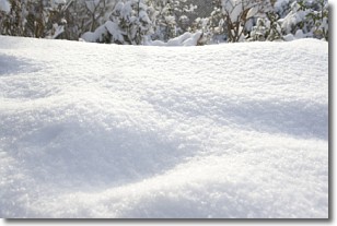
Weather Topic: What is Snow?
Home - Education - Precipitation - Snow
 Next Topic: Stratocumulus Clouds
Snow is precipitation taking the form of ice crystals. Each ice crystal, or snowflake,
has unique characteristics, but all of them grow in a hexagonal structure.
Snowfall can last for sustained periods of time and result in significant buildup
of snow on the ground.
On the earth's surface, snow starts out light and powdery, but as it begins to melt
it tends to become more granular, producing small bits of ice which have the consistency of
sand. After several cycles of melting and freezing, snow can become very dense
and ice-like, commonly known as snow pack.
Next Topic: Stratocumulus Clouds
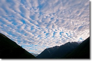
Weather Topic: What are Stratus Clouds?
Home - Education - Cloud Types - Stratus Clouds
 Next Topic: Wall Clouds
Stratus clouds are similar to altostratus clouds, but form at a
lower altitude and are identified by their fog-like appearance, lacking the
distinguishing features of most clouds.
Stratus clouds are wider than most clouds, and their base has a smooth, uniform
look which is lighter in color than a nimbostratus cloud.
The presence of a stratus cloud indicates the possibility of minor precipitation,
such as drizzle, but heavier precipitation does not typically arrive in the form
of a stratus cloud.
Next Topic: Wall Clouds
Current conditions powered by WeatherAPI.com


