Weather Alerts for Arizona
1. Air Quality Alert for: Maricopa, AZ
2. Air Quality Alert for: Pinal, AZ
3. Blowing Dust Advisory for: Gila Bend; Southeast Valley/Queen Creek; Northwest Pinal County; West Pinal County; Sonoran Desert Natl Monument
4. Blowing Dust Advisory for: Tohono O'odham Nation including Sells; Tucson Metro Area including Tucson/Green Valley/Marana/Vail; South Central Pinal County including Eloy/Picacho Peak State Park
5. Blowing Dust Advisory for: Western Pima County Including Ajo/Organ Pipe Cactus National Monument
6. Flash Flood Warning for: Santa Cruz, AZ
7. Flood Watch for: Kaibab Plateau; Marble and Glen Canyons; Grand Canyon Country
8. Flood Watch for: Parker Valley; Kofa; Yuma; Central La Paz; Southeast Yuma County; Gila River Valley; Gila Bend; Sonoran Desert Natl Monument; Imperial County Southwest; Salton Sea; Chuckwalla Mountains; Imperial County Southeast; Imperial County West; Imperial Valley; Palo Verde Valley; Chuckwalla Valley
9. Flood Watch for: Western Pima County Including Ajo/Organ Pipe Cactus National Monument; Tohono O'odham Nation including Sells; Upper Santa Cruz River and Altar Valleys including Nogales; Tucson Metro Area including Tucson/Green Valley/Marana/Vail; South Central Pinal County including Eloy/Picacho Peak State Park; Santa Catalina and Rincon Mountains including Mount Lemmon/Summerhaven; Baboquivari Mountains including Kitt Peak
10. Severe Thunderstorm Warning for: Pima, AZ
11. Severe Thunderstorm Warning for: Pima, AZ
Want more detail? Get the Complete 7 Day and Night Detailed Forecast!
Current U.S. National Radar--Current
The Current National Weather Radar is shown below with a UTC Time (subtract 5 hours from UTC to get Eastern Time).

National Weather Forecast--Current
The Current National Weather Forecast and National Weather Map are shown below.

National Weather Forecast for Tomorrow
Tomorrow National Weather Forecast and Tomorrow National Weather Map are show below.

North America Water Vapor (Moisture)
This map shows recent moisture content over North America. Bright and colored areas show high moisture (ie, clouds); brown indicates very little moisture present; black indicates no moisture.

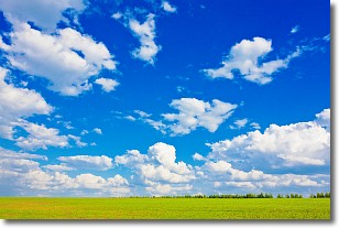
Weather Topic: What are Cumulus Clouds?
Home - Education - Cloud Types - Cumulus Clouds
 Next Topic: Drizzle
Cumulus clouds are fluffy and textured with rounded tops, and
may have flat bottoms. The border of a cumulus cloud
is clearly defined, and can have the appearance of cotton or cauliflower.
Cumulus clouds form at low altitudes (rarely above 2 km) but can grow very tall,
becoming cumulus congestus and possibly the even taller cumulonimbus clouds.
When cumulus clouds become taller, they have a greater chance of producing precipitation.
Next Topic: Drizzle
Weather Topic: What is Evaporation?
Home - Education - Precipitation - Evaporation
 Next Topic: Fog
Evaporation is the process which returns water from the earth
back to the atmosphere, and is another crucial process in the water cycle.
Evaporation is the transformation of liquid into gas, and it happens because
molecules are excited by the application of energy and turn into vapor.
In order for water to evaporate it has to be on the surface of a body of water.
Next Topic: Fog
Current conditions powered by WeatherAPI.com


