Weather Alert in District of Columbia
Extreme Cold Warning issued February 6 at 3:57PM EST until February 8 at 10:00AM EST by NWS Baltimore MD/Washington DC
AREAS AFFECTED: District of Columbia; Northern Baltimore; Cecil; Southern Baltimore; Prince Georges; Anne Arundel; Calvert; Northwest Montgomery; Central and Southeast Montgomery; Northwest Howard; Central and Southeast Howard; Northwest Harford; Southeast Harford; Fairfax; Arlington/Falls Church/Alexandria; Northern Fauquier; Western Loudoun; Eastern Loudoun; Northwest Prince William; Central and Southeast Prince William/Manassas/Manassas Park
DESCRIPTION: * WHAT...For the Extreme Cold Warning, dangerously cold wind chills around or lower than 10 degrees below zero expected. For the High Wind Warning, northwest winds 20 to 30 mph with gusts up to 60 mph expected. * WHERE...Washington D.C, and portions of central, northeast, northern, and southern Maryland, and northern Virginia. * WHEN...For the Extreme Cold Warning, from 4 AM Saturday to 10 AM EST Sunday. For the High Wind Warning, from 4 AM to 7 PM EST Saturday. * IMPACTS...Damaging winds will blow down trees and power lines. Widespread power outages are expected. Travel will be difficult, especially for high profile vehicles. The cold wind chills as low as 10 below zero could result in hypothermia if precautions are not taken. Frostbite and hypothermia will occur if unprotected skin is exposed to these temperatures. * ADDITIONAL DETAILS...Wind chills are expected to remain below zero for at least 24 hours beginning Saturday morning and continuing through late Sunday morning. Being outdoors for a prolonged period of time will be life-threatening.
INSTRUCTION: Remain in the lower levels of your home during the windstorm, and avoid windows. Watch for falling debris and tree limbs. Use caution if you must drive. Dress in layers including a hat, face mask, and gloves if you must go outside. Keep pets indoors as much as possible. Make sure outdoor animals have a warm, dry shelter, food, and unfrozen water. Make frequent checks on older family, friends, and neighbors. Ensure portable heaters are used correctly. Do not use generators or grills inside. If you do not have heat in your home or lack shelter, you can call 211 or visit your local county or city website for assistance locating appropriate shelter from the cold.
Want more detail? Get the Complete 7 Day and Night Detailed Forecast!
Current U.S. National Radar--Current
The Current National Weather Radar is shown below with a UTC Time (subtract 5 hours from UTC to get Eastern Time).

National Weather Forecast--Current
The Current National Weather Forecast and National Weather Map are shown below.

National Weather Forecast for Tomorrow
Tomorrow National Weather Forecast and Tomorrow National Weather Map are show below.

North America Water Vapor (Moisture)
This map shows recent moisture content over North America. Bright and colored areas show high moisture (ie, clouds); brown indicates very little moisture present; black indicates no moisture.

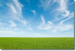
Weather Topic: What are Cirrus Clouds?
Home - Education - Cloud Types - Cirrus Clouds
 Next Topic: Condensation
Cirrus clouds are high-level clouds that occur above 20,000 feet
and are composed mainly of ice crystals.
They are thin and wispy in appearance.
What do they indicate?
They are often the first sign of an approaching storm.
Next Topic: Condensation
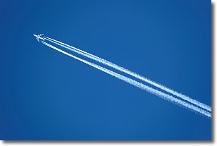
Weather Topic: What are Contrails?
Home - Education - Cloud Types - Contrails
 Next Topic: Cumulonimbus Clouds
A contrail is an artificial cloud, created by the passing of an
aircraft.
Contrails form because water vapor in the exhaust of aircraft engines is suspended
in the air under certain temperatures and humidity conditions. These contrails
are called exhaust contrails.
Another type of contrail can form due to a temporary reduction in air pressure
moving over the plane's surface, causing condensation.
These are called aerodynamic contrails.
When you can see your breath on a cold day, it is also because of condensation.
The reason contrails last longer than the condensation from your breath is
because the water in contrails freezes into ice particles.
Next Topic: Cumulonimbus Clouds
Current conditions powered by WeatherAPI.com


