Weather Alert in Maryland
High Wind Warning issued February 6 at 3:57PM EST until February 7 at 7:00PM EST by NWS Baltimore MD/Washington DC
AREAS AFFECTED: Washington; Frederick; Carroll; Central and Eastern Allegany; Augusta; Rockingham; Shenandoah; Frederick; Page; Warren; Clarke; Hampshire; Morgan; Berkeley; Jefferson; Hardy; Eastern Grant; Eastern Mineral
DESCRIPTION: * WHAT...For the High Wind Warning, northwest winds 20 to 30 mph with gusts up to 60 mph expected. For the Cold Weather Advisory, very cold wind chills as low as 10 to 25 degrees below zero expected. * WHERE...Portions of north central and western Maryland, northwest and western Virginia, and eastern and panhandle West Virginia. * WHEN...For the Extreme Cold Warning, from 4 AM Saturday to 10 AM EST Sunday. For the High Wind Warning, from 4 AM to 7 PM EST Saturday. * IMPACTS...Damaging winds will blow down trees and power lines. Widespread power outages are expected. Travel will be difficult, especially for high profile vehicles. The cold wind chills as low as 15 below zero could result in hypothermia or frostbite if precautions are not taken. * ADDITIONAL DETAILS...Wind chills will remain at or below zero during the day on Saturday due to windy conditions and cold temperatures.
INSTRUCTION: Remain in the lower levels of your home during the windstorm, and avoid windows. Watch for falling debris and tree limbs. Use caution if you must drive. Dress in layers including a hat, face mask, and gloves if you must go outside. Keep pets indoors as much as possible. Make sure outdoor animals have a warm, dry shelter, food, and unfrozen water. Make frequent checks on older family, friends, and neighbors. Ensure portable heaters are used correctly. Do not use generators or grills inside. If you do not have heat in your home or lack shelter, you can call 211 or visit your county or city website for assistance locating appropriate shelter from the cold.
Want more detail? Get the Complete 7 Day and Night Detailed Forecast!
Current U.S. National Radar--Current
The Current National Weather Radar is shown below with a UTC Time (subtract 5 hours from UTC to get Eastern Time).

National Weather Forecast--Current
The Current National Weather Forecast and National Weather Map are shown below.

National Weather Forecast for Tomorrow
Tomorrow National Weather Forecast and Tomorrow National Weather Map are show below.

North America Water Vapor (Moisture)
This map shows recent moisture content over North America. Bright and colored areas show high moisture (ie, clouds); brown indicates very little moisture present; black indicates no moisture.

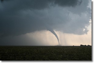
Weather Topic: What are Wall Clouds?
Home - Education - Cloud Types - Wall Clouds
 Next Topic: Altocumulus Clouds
A wall cloud forms underneath the base of a cumulonimbus cloud,
and can be a hotbed for deadly tornadoes.
Wall clouds are formed by air flowing into the cumulonimbus clouds, which can
result in the wall cloud descending from the base of the cumulonimbus cloud, or
rising fractus clouds which join to the base of the storm cloud as the wall cloud
takes shape.
Wall clouds can be very large, and in the Northern Hemisphere they generally
form at the southern edge of cumulonimbus clouds.
Next Topic: Altocumulus Clouds
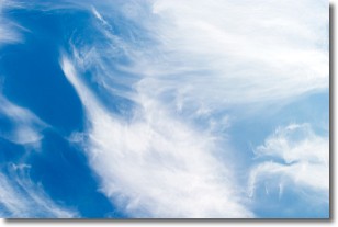
Weather Topic: What are Altostratus Clouds?
Home - Education - Cloud Types - Altostratus Clouds
 Next Topic: Cirrocumulus Clouds
Altostratus clouds form at mid to high-level altitudes
(between 2 and 7 km) and are created by a warm, stable air mass which causes
water vapor
to condense as it rise through the atmosphere. Usually altostratus clouds are
featureless sheets characterized by a uniform color.
In some cases, wind punching through the cloud formation may give it a waved
appearance, called altostratus undulatus. Altostratus clouds
are commonly seen with other cloud formations accompanying them.
Next Topic: Cirrocumulus Clouds
Current conditions powered by WeatherAPI.com


