Weather Alert in Alaska
Special Weather Statement issued August 28 at 4:05AM AKDT by NWS Anchorage AK
AREAS AFFECTED: Northern Copper Valley; Western Copper Valley; Central Copper Valley; Ernestine; Southern Copper Valley
DESCRIPTION: A frontal system moving into Southcentral will usher strong and gusty southerly winds into the Copper River Basin and Valley starting late this morning. The strongest wind gusts will range from around 35 mph to near 55 mph, with the strongest gusts focused along the Copper River Valley north of Kenny Lake and along the Richardson and Glenn Highways north and west of Glennallen. Winds will begin to diminish tonight into Friday morning as the front pushes to the east. People are urged to secure loose objects that could be blown around by the strong winds and use caution while traveling. Winds could coincide with periods of moderate rain, potentially making driving difficult at times. Trees are still fully leafed and will be unusually vulnerable to damage from the strong winds. Localized power outages will be possible due the potential for strong winds to bring down tree branches onto power lines.
INSTRUCTION: N/A
Want more detail? Get the Complete 7 Day and Night Detailed Forecast!
Current U.S. National Radar--Current
The Current National Weather Radar is shown below with a UTC Time (subtract 5 hours from UTC to get Eastern Time).

National Weather Forecast--Current
The Current National Weather Forecast and National Weather Map are shown below.

National Weather Forecast for Tomorrow
Tomorrow National Weather Forecast and Tomorrow National Weather Map are show below.

North America Water Vapor (Moisture)
This map shows recent moisture content over North America. Bright and colored areas show high moisture (ie, clouds); brown indicates very little moisture present; black indicates no moisture.

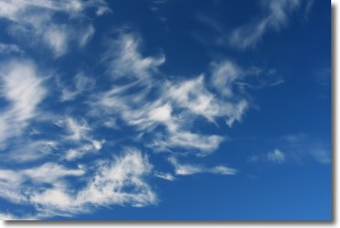
Weather Topic: What are Altostratus Clouds?
Home - Education - Cloud Types - Altostratus Clouds
 Next Topic: Cirrocumulus Clouds
Altostratus clouds form at mid to high-level altitudes
(between 2 and 7 km) and are created by a warm, stable air mass which causes
water vapor
to condense as it rise through the atmosphere. Usually altostratus clouds are
featureless sheets characterized by a uniform color.
In some cases, wind punching through the cloud formation may give it a waved
appearance, called altostratus undulatus. Altostratus clouds
are commonly seen with other cloud formations accompanying them.
Next Topic: Cirrocumulus Clouds
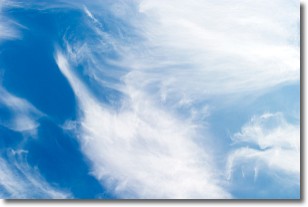
Weather Topic: What are Cirrostratus Clouds?
Home - Education - Cloud Types - Cirrostratus Clouds
 Next Topic: Cirrus Clouds
Cirrostratus clouds are high, thin clouds that form above
20,000 feet and are made mostly of ice crystals. They sometimes look like giant
feathers, horse tails, or curls of hair in the sky.
These clouds are pushed by the jet stream and can move at high speeds reaching
100 mph.
What do they indicate?
They indicate that a precipitation is likely within 24 hours.
Next Topic: Cirrus Clouds
Current conditions powered by WeatherAPI.com


