Weather Alert in Alaska
Flood Watch issued September 1 at 9:26PM AKDT until September 3 at 12:00PM AKDT by NWS Fairbanks AK
AREAS AFFECTED: South Slopes of the Western Brooks Range; Noatak Valley; Upper Kobuk Valleys; Lower Koyukuk Valley; Upper Koyukuk Valley
DESCRIPTION: * WHAT...Flooding caused by excessive rainfall continues to be possible. * WHERE...Including the Noatak, Kobuk, and Koyukuk Rivers. * WHEN...Through Wednesday morning. * IMPACTS...Excessive runoff from last week's rainfall is resulting in flooding of rivers, creeks, streams, and other low-lying and flood-prone locations. * ADDITIONAL DETAILS... - Flooding of roadways has been reported in Kobuk and Allakaket. River levels are also at flood stage in Hughes. An additional 0.50 to 1.00 inch of rainfall is expected in the Southern Brooks Range through Tuesday, which is forecast to prolong high water levels this week. Another rainmaker will arrive Wednesday evening. This may bring another 0.50 to 1.00 inch to the Southern Brooks Range. - Http://www.weather.gov/aprfc
INSTRUCTION: Persons living along streams should stay alert and be prepared to take action if a warning or advisory is issued, or flooding is observed. You should monitor later forecasts and be alert for possible Flood Warnings. Those living in areas prone to flooding should be prepared to take action should flooding develop. Stay tuned to further developments by listening to your local radio, television, or NOAA Weather Radio for further information.
Want more detail? Get the Complete 7 Day and Night Detailed Forecast!
Current U.S. National Radar--Current
The Current National Weather Radar is shown below with a UTC Time (subtract 5 hours from UTC to get Eastern Time).

National Weather Forecast--Current
The Current National Weather Forecast and National Weather Map are shown below.

National Weather Forecast for Tomorrow
Tomorrow National Weather Forecast and Tomorrow National Weather Map are show below.

North America Water Vapor (Moisture)
This map shows recent moisture content over North America. Bright and colored areas show high moisture (ie, clouds); brown indicates very little moisture present; black indicates no moisture.

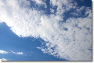
Weather Topic: What are Stratus Clouds?
Home - Education - Cloud Types - Stratus Clouds
 Next Topic: Wall Clouds
Stratus clouds are similar to altostratus clouds, but form at a
lower altitude and are identified by their fog-like appearance, lacking the
distinguishing features of most clouds.
Stratus clouds are wider than most clouds, and their base has a smooth, uniform
look which is lighter in color than a nimbostratus cloud.
The presence of a stratus cloud indicates the possibility of minor precipitation,
such as drizzle, but heavier precipitation does not typically arrive in the form
of a stratus cloud.
Next Topic: Wall Clouds
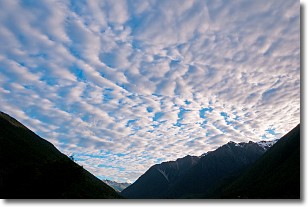
Weather Topic: What are Altocumulus Clouds?
Home - Education - Cloud Types - Altocumulus Clouds
 Next Topic: Altostratus Clouds
Similar to cirrocumulus clouds, altocumulus clouds are
characterized by cloud patches. They are distinguished by larger cloudlets
than cirrocumulus clouds but are still smaller than stratocumulus clouds.
Altocumulus clouds most commonly form in middle altitudes (between 2 and 5 km)
and may resemble, at times, the shape of a flying saucer.
These uncommon formations, called altocumulus lenticularis, are created by uplift
in the atmosphere and are most often seen in close proximity to mountains.
Next Topic: Altostratus Clouds
Current conditions powered by WeatherAPI.com


