Weather Alert in Idaho
Flash Flood Watch issued August 25 at 11:41AM MDT until August 28 at 12:00AM MDT by NWS Boise ID
AREAS AFFECTED: West Central Mountains; Lower Treasure Valley; Boise Mountains; Upper Treasure Valley; Southwest Highlands; Western Magic Valley; Camas Prairie; Owyhee Mountains; Southern Twin Falls County; Upper Weiser River; Harney County; Baker County; Malheur County; Oregon Lower Treasure Valley
DESCRIPTION: A surge of deep monsoonal moisture combined with a slow-moving upper trough will bring periods of heavy showers and thunderstorms across the region. This airmass contains anomalously high moisture content, supporting the potential for excessive rainfall. Flash flooding will be possible, especially in steep terrain, narrow canyons, and near recent burn scars where soils are less able to absorb rainfall. The greatest risk will be Tuesday afternoon through Wednesday evening as repeated rounds of storms move through. * WHAT...Flash flooding caused by excessive rainfall is possible. * WHERE...Portions of Idaho, including the following areas, Boise Mountains, Camas Prairie, Lower Treasure Valley, Owyhee Mountains, Southern Twin Falls County, Southwest Highlands, Upper Treasure Valley, Upper Weiser River, West Central Mountains and Western Magic Valley. Portions of Oregon, including the following areas, Baker County, Harney County, Malheur County and Oregon Lower Treasure Valley. * WHEN...From Tuesday afternoon through Wednesday evening. * IMPACTS...Heavy rainfall could trigger flash flooding or debris flows in and near recent wildfire burn scars. In addition urban street flooding is possible with the stronger storms. * ADDITIONAL DETAILS... - https://www.weather.gov/safety/flood
INSTRUCTION: You should monitor later forecasts and be prepared to take action should Flash Flood Warnings be issued. Local emergency services are monitoring the situation and will issue a public statement as conditions warrant. PLAN NOW so you will know what to do in an emergency. Keep informed by listening to local radio and television for statements and possible warnings. Follow the advice of public safety officials.
Want more detail? Get the Complete 7 Day and Night Detailed Forecast!
Current U.S. National Radar--Current
The Current National Weather Radar is shown below with a UTC Time (subtract 5 hours from UTC to get Eastern Time).

National Weather Forecast--Current
The Current National Weather Forecast and National Weather Map are shown below.

National Weather Forecast for Tomorrow
Tomorrow National Weather Forecast and Tomorrow National Weather Map are show below.

North America Water Vapor (Moisture)
This map shows recent moisture content over North America. Bright and colored areas show high moisture (ie, clouds); brown indicates very little moisture present; black indicates no moisture.

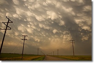
Weather Topic: What are Mammatus Clouds?
Home - Education - Cloud Types - Mammatus Clouds
 Next Topic: Nimbostratus Clouds
A mammatus cloud is a cloud with a unique feature which resembles
a web of pouches hanging along the base of the cloud.
In the United States, mammatus clouds tend to form in the warmer months, commonly
in the Midwest and eastern regions.
While they usually form at the bottom of a cumulonimbis cloud, they can also form
under altostratus, altocumulus, stratocumulus, and cirrus clouds. Mammatus clouds
warn that severe weather is close.
Next Topic: Nimbostratus Clouds
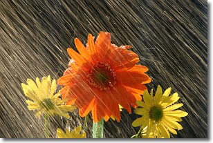
Weather Topic: What is Precipitation?
Home - Education - Precipitation - Precipitation
 Next Topic: Rain
Precipitation can refer to many different forms of water that
may fall from clouds. Precipitation occurs after a cloud has become saturated to
the point where its water particles are more dense than the air below the cloud.
In most cases, precipitation will reach the ground, but it is not uncommon for
precipitation to evaporate before it reaches the earth's surface.
When precipitation evaporates before it contacts the ground it is called Virga.
Graupel, hail, sleet, rain, drizzle, and snow are forms of precipitation, but fog
and mist are not considered precipitation because the water vapor which
constitutes them isn't dense enough to fall to the ground.
Next Topic: Rain
Current conditions powered by WeatherAPI.com


