Weather Alert in Colorado
Hydrologic Outlook issued May 9 at 10:24AM MDT by NWS Pueblo CO
AREAS AFFECTED: Alamosa, CO; Chaffee, CO; Conejos, CO; Costilla, CO; Custer, CO; Fremont, CO; Huerfano, CO; Lake, CO; Las Animas, CO; Mineral, CO; Rio Grande, CO; Saguache, CO
DESCRIPTION: ESFPUB Risk of enhanced runoff and elevated stream flows from rapid snowmelt ...EXISTING CONDITIONS... Recent storms have brought several inches of snow water equivalent to mid to high elevations (8500'->10500') over the eastern San Juan and Sangre de Cristo Mountains of south-central Colorado, and along the Continental Divide of central Colorado. With upcoming precipitation, warming temperatures, and possible rain-on-snow for mid to high elevations, this region of Colorado is vulnerable to enhanced runoff and elevated stream flows from rapid snowmelt. ...PRECIPITATION... There is a roughly 25% chance of 0.1" or more of liquid precipitation over much of the area of concern today through Saturday afternoon. Precipitation in the form of rain could occur as high as 10,000 feet. This elevated chance of rain-on-snow, along with warmer temperatures, could accelerate melting of new and existing snowpack. ...STREAMFLOW CONDITIONS AND RUNOFF FORECASTS... Streams and rivers in the area could see elevated flows of dangerously cold water over the next several days. Low lying areas and valley floors could see some minor inundation from snowmelt. Stay away from fast moving water, exercise caution near riverbanks and stay alert to watches and warnings from the National Weather Service. You can also find additional weather and water products and forecasts at the NWS Pueblo website at: Https://www.weather.gov/pub
INSTRUCTION: N/A
Want more detail? Get the Complete 7 Day and Night Detailed Forecast!
Current U.S. National Radar--Current
The Current National Weather Radar is shown below with a UTC Time (subtract 5 hours from UTC to get Eastern Time).

National Weather Forecast--Current
The Current National Weather Forecast and National Weather Map are shown below.

National Weather Forecast for Tomorrow
Tomorrow National Weather Forecast and Tomorrow National Weather Map are show below.

North America Water Vapor (Moisture)
This map shows recent moisture content over North America. Bright and colored areas show high moisture (ie, clouds); brown indicates very little moisture present; black indicates no moisture.

Weather Topic: What is Hail?
Home - Education - Precipitation - Hail
 Next Topic: Hole Punch Clouds
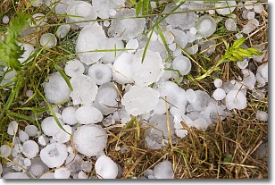
Hail is a form of precipitation which is recognized by large solid balls or
clumps of ice. Hail is created by thunderstorm clouds with strong updrafts of wind.
As the hailstones remain in the updraft, ice is deposited onto them until their
weight becomes heavy enough for them to fall to the earth's surface.
Hail storms can cause significant damage to crops, aircrafts, and man-made structures,
despite the fact that the duration is usually less than ten minutes.
Next Topic: Hole Punch Clouds
Weather Topic: What are Mammatus Clouds?
Home - Education - Cloud Types - Mammatus Clouds
 Next Topic: Nimbostratus Clouds
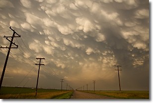
A mammatus cloud is a cloud with a unique feature which resembles
a web of pouches hanging along the base of the cloud.
In the United States, mammatus clouds tend to form in the warmer months, commonly
in the Midwest and eastern regions.
While they usually form at the bottom of a cumulonimbis cloud, they can also form
under altostratus, altocumulus, stratocumulus, and cirrus clouds. Mammatus clouds
warn that severe weather is close.
Next Topic: Nimbostratus Clouds
Current conditions powered by WeatherAPI.com


