Weather Alert in North Carolina
Flood Advisory issued July 9 at 9:22PM EDT until July 10 at 12:15AM EDT by NWS Greenville-Spartanburg SC
AREAS AFFECTED: Caldwell, NC
DESCRIPTION: * WHAT...Nuisance flooding caused by excessive rainfall is expected. * WHERE...A portion of western North Carolina, including the following county, Caldwell. * WHEN...Until 1215 AM EDT. * IMPACTS...Nuisance to Minor flooding of low-lying areas adjacent to streams and other poor-drainage areas, including farmland, parks, greenways, boat-access areas, golf courses, underpasses, and parking lots. Isolated, shallow flows over roadways is possible. A few flood-prone, low-water crossings may become impassible. A small culvert washout or two is possible. * ADDITIONAL DETAILS... - At 913 PM EDT, Doppler radar and automated rain gauges indicated heavy rain is ongoing due to multiple slow-moving thunderstorm cells across north central and northeastern Caldwell County from Buffalo Cove to Patterson, Lenoir, Cedar Rock, and Kings Creek. Between 1.5 and 2.5 inches of rain has fallen over the past 1-2 hours, prompting concerns for excessive runoff capable of producing areas of nuisance to Minor flooding. Areas of greatest concern include along Hawkins Creek near Nubbins Creek Rd, Buffalo Creek near Buffalo Cove Rd, and Kings Creek near Grandin Rd and Zacks Fork Rd. - Rainfall is slowly departing the area to the south and east. Another 1-2 inches of rainfall is possible, especially along the Lower Creek watershed from Cedar Rock to Lenoir. This may result in isolated areas of nuisance flooding over the next 1-2 hours. - Some locations that may experience nuisance flooding include... Lenoir, Cedar Rock, Patterson and Kings Creek. - http://www.weather.gov/safety/flood
INSTRUCTION: Be especially cautious at night when it is harder to recognize the dangers of flooding. Be aware of your surroundings and do not drive on flooded roads. In hilly terrain there are hundreds of low water crossings which are potentially dangerous in heavy rain. Do not attempt to cross flooded roads. Find an alternate route.
Want more detail? Get the Complete 7 Day and Night Detailed Forecast!
Current U.S. National Radar--Current
The Current National Weather Radar is shown below with a UTC Time (subtract 5 hours from UTC to get Eastern Time).

National Weather Forecast--Current
The Current National Weather Forecast and National Weather Map are shown below.

National Weather Forecast for Tomorrow
Tomorrow National Weather Forecast and Tomorrow National Weather Map are show below.

North America Water Vapor (Moisture)
This map shows recent moisture content over North America. Bright and colored areas show high moisture (ie, clouds); brown indicates very little moisture present; black indicates no moisture.

Weather Topic: What is Sleet?
Home - Education - Precipitation - Sleet
 Next Topic: Snow
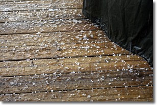
Sleet is a form of precipitation in which small ice pellets are the primary
components. These ice pellets are smaller and more translucent than hailstones,
and harder than graupel. Sleet is caused by specific atmospheric conditions and
therefore typically doesn't last for extended periods of time.
The condition which leads to sleet formation requires a warmer body of air to be
wedged in between two sub-freezing bodies of air. When snow falls through a warmer
layer of air it melts, and as it falls through the next sub-freezing body of air
it freezes again, forming ice pellets known as sleet. In some cases, water
droplets don't have time to freeze before reaching the surface and the result is
freezing rain.
Next Topic: Snow
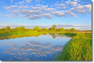
Weather Topic: What are Stratocumulus Clouds?
Home - Education - Cloud Types - Stratocumulus Clouds
 Next Topic: Stratus Clouds
Stratocumulus clouds are similar to altocumulus clouds in their
fluffy appearance, but have a slightly darker shade due to their additional mass.
A good way to distinguish the two cloud types is to hold your hand out and measure
the size of an individual cloud; if it is the size of your thumb it is generally
an altocumulus cloud, if it is the size of your hand it is generally a
stratocumulus cloud.
It is uncommon for stratocumulus clouds to produce precipitation, but if they do
it is usually a light rain or snow.
Next Topic: Stratus Clouds
Current conditions powered by WeatherAPI.com


