Weather Alert in Alaska
Hydrologic Outlook issued August 28 at 8:21AM AKDT by NWS Fairbanks AK
AREAS AFFECTED: South Slopes Of The Central Brooks Range; South Slopes of the Western Brooks Range; Noatak Valley; Lower Kobuk Valley; Upper Kobuk Valleys; Lower Koyukuk Valley; Upper Koyukuk Valley
DESCRIPTION: ESFAFG The headwater tributaries of the Koyukuk, Kobuk and Noatak Rivers have received substantial rainfall in the last several days leading to record crests at Slate Creek near Coldfoot (30 years of record) and Dahl Creek near Kobuk (39 years of record). An additional 0.5" to 1.5" of rainfall is expected to continue in the Western and Central Brooks Range through Friday, keeping water levels on rivers high and continued standing water in poorly drained areas. The crests from the early week rainfall are making their way down the main stems of the Kobuk, Koyukuk, and Noatak Rivers through the end of the week. Expect river levels to remain high through the weekend.
INSTRUCTION: N/A
Want more detail? Get the Complete 7 Day and Night Detailed Forecast!
Current U.S. National Radar--Current
The Current National Weather Radar is shown below with a UTC Time (subtract 5 hours from UTC to get Eastern Time).

National Weather Forecast--Current
The Current National Weather Forecast and National Weather Map are shown below.

National Weather Forecast for Tomorrow
Tomorrow National Weather Forecast and Tomorrow National Weather Map are show below.

North America Water Vapor (Moisture)
This map shows recent moisture content over North America. Bright and colored areas show high moisture (ie, clouds); brown indicates very little moisture present; black indicates no moisture.

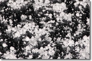
Weather Topic: What is Graupel?
Home - Education - Precipitation - Graupel
 Next Topic: Hail
Graupel is a form of precipitation that is created by atmospheric conditions
which cause supercooled water droplets to contact snow crystals and freeze to
their surface.
Sometimes known as soft hail or snow pellets, graupel is delicate and easily
destroyed by touch. Whereas hail usually falls during severe weather, graupel
doesn't require such conditions to form, and can form in mild precipitation
similar to situations which produce snowfall.
Next Topic: Hail
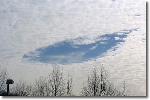
Weather Topic: What are Hole Punch Clouds?
Home - Education - Cloud Types - Hole Punch Clouds
 Next Topic: Mammatus Clouds
A hole punch cloud is an unusual occurrence when a disk-shaped
hole appears in a cirrostratus, cirrocumulus, or altocumulus cloud.
When part of the cloud forms ice crystals, water droplets in the surrounding area
of the cloud evaporate. The effect of this process produces a large elliptical
gap in the cloud. The hole punch cloud formation is rare, but it is not specific
to any geographic area.
Other names which have been used to describe this phenomena include fallstreak hole,
skypunch, and cloud hole.
Next Topic: Mammatus Clouds
Current conditions powered by WeatherAPI.com


