Weather Alert in Pennsylvania
Special Weather Statement issued February 11 at 2:11PM EST by NWS State College PA
AREAS AFFECTED: Warren; McKean; Elk; Clearfield; Cambria; Somerset
DESCRIPTION: Deepening cold and relatively moist air being lifted across the Mountains of Western Pennsylvania will result in fairly persistent light snow late today through Thursday. Snowfall rates will peak at only around one-quarter of an inch per hour for much of the area along and to the east of the Route 219 corridor. However, a few periods of snowfall rates of one half inch per hour or greater will likely occur in the areas of greatest upslope flow, such as the ski areas of the Laurel Highlands and the perennial snowbelt of Northern Warren County. Total snowfall during this 24 to 30 hour period will range from just an inch or two in the valleys near and to the east of Route 219, to as much as 4 or 5 inches along the crest of Laurel Ridge in Somerset County. Roads could become snow covered and slippery tonight and Thursday as temperatures settle into the upper teens to low 20s for the bulk of the time. Use extra caution and allow extra time to reach your destination if you plan to travel.
INSTRUCTION: N/A
Want more detail? Get the Complete 7 Day and Night Detailed Forecast!
Current U.S. National Radar--Current
The Current National Weather Radar is shown below with a UTC Time (subtract 5 hours from UTC to get Eastern Time).

National Weather Forecast--Current
The Current National Weather Forecast and National Weather Map are shown below.

National Weather Forecast for Tomorrow
Tomorrow National Weather Forecast and Tomorrow National Weather Map are show below.

North America Water Vapor (Moisture)
This map shows recent moisture content over North America. Bright and colored areas show high moisture (ie, clouds); brown indicates very little moisture present; black indicates no moisture.

Weather Topic: What are Shelf Clouds?
Home - Education - Cloud Types - Shelf Clouds
 Next Topic: Sleet
A shelf cloud is similar to a wall cloud, but forms at the front
of a storm cloud, instead of at the rear, where wall clouds form.
A shelf cloud is caused by a series of events set into motion by the advancing
storm; first, cool air settles along the ground where precipitation has just fallen.
As the cool air is brought in, the warmer air is displaced, and rises above it,
because it is less dense. When the warmer air reaches the bottom of the storm cloud,
it begins to cool again, and the resulting condensation is a visible shelf cloud.
Next Topic: Sleet
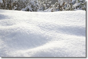
Weather Topic: What is Snow?
Home - Education - Precipitation - Snow
 Next Topic: Stratocumulus Clouds
Snow is precipitation taking the form of ice crystals. Each ice crystal, or snowflake,
has unique characteristics, but all of them grow in a hexagonal structure.
Snowfall can last for sustained periods of time and result in significant buildup
of snow on the ground.
On the earth's surface, snow starts out light and powdery, but as it begins to melt
it tends to become more granular, producing small bits of ice which have the consistency of
sand. After several cycles of melting and freezing, snow can become very dense
and ice-like, commonly known as snow pack.
Next Topic: Stratocumulus Clouds
Current conditions powered by WeatherAPI.com


