Weather Alert in North Carolina
Flood Advisory issued July 9 at 9:35PM EDT until July 10 at 1:00AM EDT by NWS Greenville-Spartanburg SC
AREAS AFFECTED: Catawba, NC; Iredell, NC
DESCRIPTION: * WHAT...Nuisance to Minor flooding caused by excessive rainfall continues. * WHERE...A portion of piedmont North Carolina, including the following counties, Catawba and Iredell. * WHEN...Until 100 AM EDT. * IMPACTS...Nuisance to Minor flooding of low-lying areas adjacent to streams and other poor-drainage areas, including farmland, parks, greenways, boat-access areas, golf courses, underpasses, and parking lots. Isolated, shallow flows over roadways is possible. A few flood-prone, low-water crossings may become impassible. A small culvert washout or two is possible. * ADDITIONAL DETAILS... - At 932 PM EDT, Doppler radar and automated rain gauges indicated heavy rain is ongoing due to multiple slow-moving thunderstorm cells over southeastern central and eastern Catawba County. Between 1 and 3 inches of rain has fallen. Areas of greatest concern include along Lyle Creek near Section House Rd, County Home Rd, the Rock Bard Golf and Spa, and NC 16, the confluence of Lyle Creek and Mull Creek near Bunker Hill School Rd. Urbanized areas of Newton, Concord, Claremont, and Catawba, including along and near US 70 and I-40, may experience areas of deep ponding due to poor draining and overflowing small feeder streams. - An additional 0.5-1.0 inch of rain is possible over the next hour or two due to these very slow-moving cells and the movement of additional thunderstorm cells into the Advisory area from the south and west. This rainfall may exacerbate developing flooding or cause new areas of flooding to develop. Caution is advised near any stream or other vulnerable area. Seek higher ground immediately if streams start to rise. Please have a plan in place should flash flooding develop and do not hesitate to act. - Some locations that may experience nuisance to Minor flooding include... Hickory, Newton, St. Stephens, Conover, Stony Point, Claremont, Catawba, Lake Norman State Park, Sherrills Ford, Bandys, Scotts and Startown. - http://www.weather.gov/safety/flood
INSTRUCTION: Be especially cautious at night when it is harder to recognize the dangers of flooding. Be aware of your surroundings and do not drive on flooded roads.
Want more detail? Get the Complete 7 Day and Night Detailed Forecast!
Current U.S. National Radar--Current
The Current National Weather Radar is shown below with a UTC Time (subtract 5 hours from UTC to get Eastern Time).

National Weather Forecast--Current
The Current National Weather Forecast and National Weather Map are shown below.

National Weather Forecast for Tomorrow
Tomorrow National Weather Forecast and Tomorrow National Weather Map are show below.

North America Water Vapor (Moisture)
This map shows recent moisture content over North America. Bright and colored areas show high moisture (ie, clouds); brown indicates very little moisture present; black indicates no moisture.

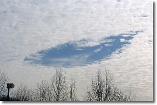
Weather Topic: What are Hole Punch Clouds?
Home - Education - Cloud Types - Hole Punch Clouds
 Next Topic: Mammatus Clouds
A hole punch cloud is an unusual occurrence when a disk-shaped
hole appears in a cirrostratus, cirrocumulus, or altocumulus cloud.
When part of the cloud forms ice crystals, water droplets in the surrounding area
of the cloud evaporate. The effect of this process produces a large elliptical
gap in the cloud. The hole punch cloud formation is rare, but it is not specific
to any geographic area.
Other names which have been used to describe this phenomena include fallstreak hole,
skypunch, and cloud hole.
Next Topic: Mammatus Clouds
Weather Topic: What are Nimbostratus Clouds?
Home - Education - Cloud Types - Nimbostratus Clouds
 Next Topic: Precipitation
A nimbostratus cloud is similar to a stratus cloud in its formless,
smooth appearance. However, a nimbostratus cloud is darker than a stratus cloud,
because it is thicker.
Unlike a stratus cloud, a nimbostratus cloud typically brings with it the threat
of moderate to heavy precipitation. In some cases, the precipitation may evaporate
before reaching the ground, a phenomenon known as virga.
Next Topic: Precipitation
Current conditions powered by WeatherAPI.com


