Weather Alert in Alaska
Winter Weather Advisory issued August 25 at 7:58PM AKDT until August 28 at 7:00AM AKDT by NWS Fairbanks AK
AREAS AFFECTED: Central Beaufort Sea Coast; Central Arctic Plains; Central Brooks Range
DESCRIPTION: * WHAT...Mixed precipitation expected. Total snow accumulations up to 2 inch inches north of the Brooks Range and up to 1 inch in the Brooks Range and ice accumulations around a light glaze. * WHERE...Central Arctic Plains, Central Beaufort Sea Coast, and Central Brooks Range. * WHEN...From 10 PM Tuesday to 7 AM AKDT Thursday. * IMPACTS...Plan on slippery road conditions. Any accumulating snow and freezing rain could create difficult travel conditions. * ADDITIONAL DETAILS...There is very high uncertainty in exact accumulations. Freezing rain is possible everywhere, especially in the Brooks Range and along the Dalton Highway south of Prudhoe Bay. Temperatures will hover around 32 degrees, especially Tuesday night and Wednesday night which will make things difficult to accumulate unless precipitation rates are heavy enough to overcome warm ground temperatures. The greatest risk for accumulating snow will be north of the Brooks Range and towards the coast, while the greatest risk for freezing rain accumulations resides in the Brooks Range. The Dalton Highway in between has equal chances for both.
INSTRUCTION: Slow down and use caution while traveling. The latest road conditions for the state you are calling from can be obtained by calling 5 1 1.
Want more detail? Get the Complete 7 Day and Night Detailed Forecast!
Current U.S. National Radar--Current
The Current National Weather Radar is shown below with a UTC Time (subtract 5 hours from UTC to get Eastern Time).

National Weather Forecast--Current
The Current National Weather Forecast and National Weather Map are shown below.

National Weather Forecast for Tomorrow
Tomorrow National Weather Forecast and Tomorrow National Weather Map are show below.

North America Water Vapor (Moisture)
This map shows recent moisture content over North America. Bright and colored areas show high moisture (ie, clouds); brown indicates very little moisture present; black indicates no moisture.

Weather Topic: What are Altocumulus Clouds?
Home - Education - Cloud Types - Altocumulus Clouds
 Next Topic: Altostratus Clouds
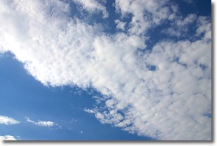
Similar to cirrocumulus clouds, altocumulus clouds are
characterized by cloud patches. They are distinguished by larger cloudlets
than cirrocumulus clouds but are still smaller than stratocumulus clouds.
Altocumulus clouds most commonly form in middle altitudes (between 2 and 5 km)
and may resemble, at times, the shape of a flying saucer.
These uncommon formations, called altocumulus lenticularis, are created by uplift
in the atmosphere and are most often seen in close proximity to mountains.
Next Topic: Altostratus Clouds
Weather Topic: What are Cirrocumulus Clouds?
Home - Education - Cloud Types - Cirrocumulus Clouds
 Next Topic: Cirrostratus Clouds
Cirrocumulus clouds form at high altitudes (usually around 5 km)
and have distinguishing characteristics displayed in a fine layer of
small cloud patches. These small cloud patches are sometimes referred to as
"cloudlets" in relation to the whole cloud formation.
Cirrocumulus clouds are formed from ice crystals and water droplets. Often, the
water droplets in the cloud freeze into ice crystals and the cloud becomes a
cirrostratus cloud. Because of this common occurrence, cirrocumulus cloud
formations generally pass rapidly.
Next Topic: Cirrostratus Clouds
Current conditions powered by WeatherAPI.com


