Weather Alert in Alaska
Winter Weather Advisory issued August 25 at 7:58PM AKDT until August 28 at 7:00AM AKDT by NWS Fairbanks AK
AREAS AFFECTED: Central Beaufort Sea Coast; Central Arctic Plains; Central Brooks Range
DESCRIPTION: * WHAT...Mixed precipitation expected. Total snow accumulations up to 2 inch inches north of the Brooks Range and up to 1 inch in the Brooks Range and ice accumulations around a light glaze. * WHERE...Central Arctic Plains, Central Beaufort Sea Coast, and Central Brooks Range. * WHEN...From 10 PM Tuesday to 7 AM AKDT Thursday. * IMPACTS...Plan on slippery road conditions. Any accumulating snow and freezing rain could create difficult travel conditions. * ADDITIONAL DETAILS...There is very high uncertainty in exact accumulations. Freezing rain is possible everywhere, especially in the Brooks Range and along the Dalton Highway south of Prudhoe Bay. Temperatures will hover around 32 degrees, especially Tuesday night and Wednesday night which will make things difficult to accumulate unless precipitation rates are heavy enough to overcome warm ground temperatures. The greatest risk for accumulating snow will be north of the Brooks Range and towards the coast, while the greatest risk for freezing rain accumulations resides in the Brooks Range. The Dalton Highway in between has equal chances for both.
INSTRUCTION: Slow down and use caution while traveling. The latest road conditions for the state you are calling from can be obtained by calling 5 1 1.
Want more detail? Get the Complete 7 Day and Night Detailed Forecast!
Current U.S. National Radar--Current
The Current National Weather Radar is shown below with a UTC Time (subtract 5 hours from UTC to get Eastern Time).

National Weather Forecast--Current
The Current National Weather Forecast and National Weather Map are shown below.

National Weather Forecast for Tomorrow
Tomorrow National Weather Forecast and Tomorrow National Weather Map are show below.

North America Water Vapor (Moisture)
This map shows recent moisture content over North America. Bright and colored areas show high moisture (ie, clouds); brown indicates very little moisture present; black indicates no moisture.

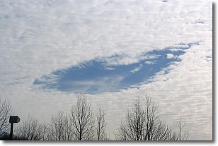
Weather Topic: What are Hole Punch Clouds?
Home - Education - Cloud Types - Hole Punch Clouds
 Next Topic: Mammatus Clouds
A hole punch cloud is an unusual occurrence when a disk-shaped
hole appears in a cirrostratus, cirrocumulus, or altocumulus cloud.
When part of the cloud forms ice crystals, water droplets in the surrounding area
of the cloud evaporate. The effect of this process produces a large elliptical
gap in the cloud. The hole punch cloud formation is rare, but it is not specific
to any geographic area.
Other names which have been used to describe this phenomena include fallstreak hole,
skypunch, and cloud hole.
Next Topic: Mammatus Clouds
Weather Topic: What are Nimbostratus Clouds?
Home - Education - Cloud Types - Nimbostratus Clouds
 Next Topic: Precipitation
A nimbostratus cloud is similar to a stratus cloud in its formless,
smooth appearance. However, a nimbostratus cloud is darker than a stratus cloud,
because it is thicker.
Unlike a stratus cloud, a nimbostratus cloud typically brings with it the threat
of moderate to heavy precipitation. In some cases, the precipitation may evaporate
before reaching the ground, a phenomenon known as virga.
Next Topic: Precipitation
Current conditions powered by WeatherAPI.com


