Weather Alert in Arizona
Flash Flood Warning issued August 25 at 9:39PM MST until August 25 at 11:00PM MST by NWS Flagstaff AZ
AREAS AFFECTED: Yavapai, AZ
DESCRIPTION: At 939 PM MST, Doppler radar indicated that heavy rain has ended across the warned area. Between 1.5 and 2.5 inches of rain fell earlier this evening. Additional rainfall amounts of 0.1 to 0.2 inches are possible in the warned area. Flash flooding is ongoing or expected to begin shortly. HAZARD...Life threatening flash flooding. Thunderstorms producing flash flooding. SOURCE...Radar indicated. IMPACT...Life threatening flash flooding of creeks and streams, normally dry washes. Some locations that will experience flash flooding include... Castle Hot Springs, Coles Bay, Castle Creek Boat Ramp, Goose Bay, Cottonwood Day Use Area, Humbug Bay, Lake Pleasant, Humbug, Casa Rosa, Crown King and Castle Creek Wilderness. This includes the following creeks, washes and rivers... Buckhorn Creek, Buzzard Roost Creek, Ash Creek, Tuscumbia Creek, Humbug Creek, Boulder Creek, Jim Creek, Cherry Creek, East Fork Castle Creek, Bitter Creek, Tiger Creek, Cottonwood Creek, Bear Creek, Cellar Springs Creek, Poland Creek, North Fork Cellar Springs Creek, Black Butte Wash, Oak Creek, Sand Creek, Tussock Spring Creek, Banty Creek, Castle Creek, French Creek, Minnehaha Creek and Whipsaw Creek.
INSTRUCTION: Be especially cautious at night when it is harder to recognize the dangers of flooding. Stay away or be swept away! The banks of creeks and washes are unstable and unsafe during any flooding event. Get out of washes and creeks if you are camping or hiking! Flooding is occurring or imminent and will inundate creeks and washes.
Want more detail? Get the Complete 7 Day and Night Detailed Forecast!
Current U.S. National Radar--Current
The Current National Weather Radar is shown below with a UTC Time (subtract 5 hours from UTC to get Eastern Time).

National Weather Forecast--Current
The Current National Weather Forecast and National Weather Map are shown below.

National Weather Forecast for Tomorrow
Tomorrow National Weather Forecast and Tomorrow National Weather Map are show below.

North America Water Vapor (Moisture)
This map shows recent moisture content over North America. Bright and colored areas show high moisture (ie, clouds); brown indicates very little moisture present; black indicates no moisture.

Weather Topic: What is Sleet?
Home - Education - Precipitation - Sleet
 Next Topic: Snow
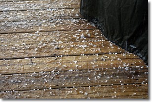
Sleet is a form of precipitation in which small ice pellets are the primary
components. These ice pellets are smaller and more translucent than hailstones,
and harder than graupel. Sleet is caused by specific atmospheric conditions and
therefore typically doesn't last for extended periods of time.
The condition which leads to sleet formation requires a warmer body of air to be
wedged in between two sub-freezing bodies of air. When snow falls through a warmer
layer of air it melts, and as it falls through the next sub-freezing body of air
it freezes again, forming ice pellets known as sleet. In some cases, water
droplets don't have time to freeze before reaching the surface and the result is
freezing rain.
Next Topic: Snow
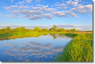
Weather Topic: What are Stratocumulus Clouds?
Home - Education - Cloud Types - Stratocumulus Clouds
 Next Topic: Stratus Clouds
Stratocumulus clouds are similar to altocumulus clouds in their
fluffy appearance, but have a slightly darker shade due to their additional mass.
A good way to distinguish the two cloud types is to hold your hand out and measure
the size of an individual cloud; if it is the size of your thumb it is generally
an altocumulus cloud, if it is the size of your hand it is generally a
stratocumulus cloud.
It is uncommon for stratocumulus clouds to produce precipitation, but if they do
it is usually a light rain or snow.
Next Topic: Stratus Clouds
Current conditions powered by WeatherAPI.com


