Weather Alert in Oklahoma
Flood Advisory issued August 25 at 7:44PM CDT until August 27 at 7:00PM CDT by NWS Norman OK
AREAS AFFECTED: Dewey, OK; Major, OK; Woodward, OK
DESCRIPTION: ...The Flood Advisory continues for the following rivers in Oklahoma... North Canadian River near Seiling affecting Dewey, Woodward and Major Counties. * WHAT...Flooding caused by excessive rainfall continues. * WHERE...North Canadian River near Seiling. * WHEN...Until Wednesday evening. * IMPACTS...At 10.0 feet, Some croplands... pastures... and rural roads may be flooded. Areas affected extend from the southwest corner of Major County... downstream to the headwaters of Canton Lake in Dewey County. Cattle and other property should be relocated to places which are higher than nearby river banks... to avoid being isolated for several hours by water in side channels. * ADDITIONAL DETAILS... - At 7:00 PM CDT Monday the stage was 4.5 feet. - Bankfull stage is 11.0 feet. - Forecast...The North Canadian River is expected to rise to a crest of 10.2 feet tomorrow evening. - Action stage is 9.0 feet. - Flood stage is 11.0 feet. - http://www.weather.gov/safety/flood
INSTRUCTION: If you encounter a flooded roadway, turn around and find an alternative route. Additional information is available at www.weather.gov.
Want more detail? Get the Complete 7 Day and Night Detailed Forecast!
Current U.S. National Radar--Current
The Current National Weather Radar is shown below with a UTC Time (subtract 5 hours from UTC to get Eastern Time).

National Weather Forecast--Current
The Current National Weather Forecast and National Weather Map are shown below.

National Weather Forecast for Tomorrow
Tomorrow National Weather Forecast and Tomorrow National Weather Map are show below.

North America Water Vapor (Moisture)
This map shows recent moisture content over North America. Bright and colored areas show high moisture (ie, clouds); brown indicates very little moisture present; black indicates no moisture.

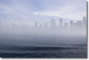
Weather Topic: What is Fog?
Home - Education - Cloud Types - Fog
 Next Topic: Fractus Clouds
Fog is technically a type of stratus cloud, which lies along the
ground and obscures visibility.
It is usually created when humidity in the air condenses into tiny water droplets.
Because of this, some places are more prone to foggy weather, such as regions
close to a body of water.
Fog is similar to mist; both are the appearance of water droplets suspended in
the air, but fog is the term applied to the condition when visibility is less than 1 km.
Next Topic: Fractus Clouds
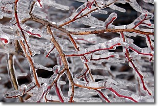
Weather Topic: What is Freezing Rain?
Home - Education - Precipitation - Freezing Rain
 Next Topic: Graupel
Freezing rain is a condition where precipitation which has fallen in the form of
water droplets reaches temperatures which are below freezing and freezes upon
coming into contact
with surface objects. The result of this precipitation is a glaze of ice which
can be damaging to plants and man-made structures. A severe onset of freezing
rain which results in a very thick glaze of ice is known as an ice storm.
Next Topic: Graupel
Current conditions powered by WeatherAPI.com


