Weather Alert in Hawaii
Flood Watch issued February 6 at 3:42AM HST until February 9 at 6:00PM HST by NWS Honolulu HI
AREAS AFFECTED: Niihau; Kauai Southwest; Kauai Mountains; Waianae Coast; Oahu North Shore; Olomana; Central Oahu; Waianae Mountains; Lanai Mauka; Kahoolawe; Maui Windward West; Maui Leeward West; Haleakala Summit; Kona; Kohala; Big Island Interior; Kauai North; Kauai East; Kauai South; East Honolulu; Honolulu Metro; Ewa Plain; Koolau Windward; Koolau Leeward; Molokai Windward; Molokai Southeast; Molokai North; Molokai West; Molokai Leeward South; Lanai Windward; Lanai Leeward; Lanai South; Maui Central Valley North; Maui Central Valley South; Windward Haleakala; Kipahulu; South Maui/Upcountry; South Haleakala; Big Island South; Big Island Southeast; Big Island East; Big Island North
DESCRIPTION: ...FLOOD WATCH IN EFFECT FOR ALL HAWAIIAN ISLANDS FROM SATURDAY AFTERNOON THROUGH MONDAY AFTERNOON... * WHAT...Flash flooding caused by excessive rainfall is possible. * WHERE...All the main Hawaiian islands. * WHEN...From Saturday afternoon through Monday afternoon. * IMPACTS...Flood prone roads and other low lying areas may be closed due to elevated runoff and overflowing streams. Urban areas may receive more significant flooding and property damage due to rapid runoff. * ADDITIONAL DETAILS... - A front will move southeast into Kauai late this afternoon, then through Oahu and into Maui County tonight. The front will stall over Maui County this weekend, allowing deep tropical moisture to pool over the island chain. This in combination with a disturbance aloft moving over the state, will bring the potential for heavy rainfall, a few thunderstorms and flash flooding beginning Saturday afternoon and continuing through Monday afternoon. The greatest risk for flash flooding is expected in windward areas.
INSTRUCTION: You should monitor later forecasts and be prepared to take action should Flash Flood Warnings be issued.
Want more detail? Get the Complete 7 Day and Night Detailed Forecast!
Current U.S. National Radar--Current
The Current National Weather Radar is shown below with a UTC Time (subtract 5 hours from UTC to get Eastern Time).

National Weather Forecast--Current
The Current National Weather Forecast and National Weather Map are shown below.

National Weather Forecast for Tomorrow
Tomorrow National Weather Forecast and Tomorrow National Weather Map are show below.

North America Water Vapor (Moisture)
This map shows recent moisture content over North America. Bright and colored areas show high moisture (ie, clouds); brown indicates very little moisture present; black indicates no moisture.

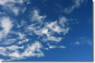
Weather Topic: What are Cirrostratus Clouds?
Home - Education - Cloud Types - Cirrostratus Clouds
 Next Topic: Cirrus Clouds
Cirrostratus clouds are high, thin clouds that form above
20,000 feet and are made mostly of ice crystals. They sometimes look like giant
feathers, horse tails, or curls of hair in the sky.
These clouds are pushed by the jet stream and can move at high speeds reaching
100 mph.
What do they indicate?
They indicate that a precipitation is likely within 24 hours.
Next Topic: Cirrus Clouds
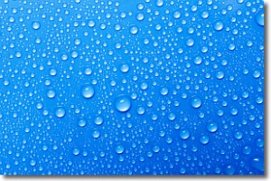
Weather Topic: What is Condensation?
Home - Education - Precipitation - Condensation
 Next Topic: Contrails
Condensation is the process which creates clouds, and therefore
it is a crucial process in the water cycle.
Condensation is the change of matter from a state of gas into a state of liquid,
and it happens because water molecules release heat into the atmosphere and
become organized into a more closely packed structure, what we might see as
water droplets.
Water is always present in the air around us as a vapor, but it's too small for
us to see. When water undergoes the process of condensation it becomes organized
into visible water droplets. You've probably seen condensation happen before on the
surface of a cold drink!
Next Topic: Contrails
Current conditions powered by WeatherAPI.com


