Weather Alert in New Mexico
Flood Watch issued August 26 at 11:10AM MDT until August 27 at 12:00AM MDT by NWS Albuquerque NM
AREAS AFFECTED: Southern Sangre de Cristo Mountains; East Slopes Sangre de Cristo Mountains; South Central Mountains; Northeast Highlands
DESCRIPTION: * WHAT...Flash flooding caused by excessive rainfall continues to be possible. * WHERE...Portions of central, north central, and northeast New Mexico, including the following areas, in central New Mexico, South Central Mountains. In north central New Mexico, East Slopes Sangre de Cristo Mountains and Southern Sangre de Cristo Mountains. In northeast New Mexico, Northeast Highlands. * WHEN...Through this evening. * IMPACTS...Excessive runoff may result in flooding of rivers, creeks, streams, and other low-lying and flood-prone locations. Creeks and streams may rise out of their banks. Storm drains and ditches may become clogged with debris. * ADDITIONAL DETAILS... - Numerous thunderstorms will develop over the northern mountains this afternoon and evening, with scattered to numerous coverage of storms over the south central mountains. Some of the stronger storms will be capable of producing rain at rates over 1 inch per hour, and some locations may receive multiple storms. Locations where the ground is already saturated from heavy rainfall, recent burn scars, and urban areas will be especially susceptible to rapid runoff and flash flooding. On Monday, the western third of the San Miguel County part of the Hermits Peak Calf Canyon scar accumulated 1 to 2 inches of rainfall, so rapid runoff is likely there today. - http://www.weather.gov/safety/flood
INSTRUCTION: Turn around, don't drown when encountering flooded roads. Most flood deaths occur in vehicles.
Want more detail? Get the Complete 7 Day and Night Detailed Forecast!
Current U.S. National Radar--Current
The Current National Weather Radar is shown below with a UTC Time (subtract 5 hours from UTC to get Eastern Time).

National Weather Forecast--Current
The Current National Weather Forecast and National Weather Map are shown below.

National Weather Forecast for Tomorrow
Tomorrow National Weather Forecast and Tomorrow National Weather Map are show below.

North America Water Vapor (Moisture)
This map shows recent moisture content over North America. Bright and colored areas show high moisture (ie, clouds); brown indicates very little moisture present; black indicates no moisture.

Weather Topic: What is Freezing Rain?
Home - Education - Precipitation - Freezing Rain
 Next Topic: Graupel
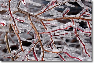
Freezing rain is a condition where precipitation which has fallen in the form of
water droplets reaches temperatures which are below freezing and freezes upon
coming into contact
with surface objects. The result of this precipitation is a glaze of ice which
can be damaging to plants and man-made structures. A severe onset of freezing
rain which results in a very thick glaze of ice is known as an ice storm.
Next Topic: Graupel
Weather Topic: What is Hail?
Home - Education - Precipitation - Hail
 Next Topic: Hole Punch Clouds
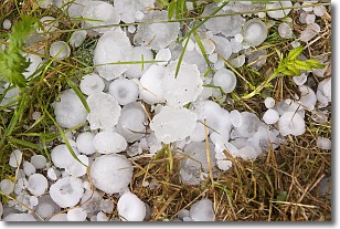
Hail is a form of precipitation which is recognized by large solid balls or
clumps of ice. Hail is created by thunderstorm clouds with strong updrafts of wind.
As the hailstones remain in the updraft, ice is deposited onto them until their
weight becomes heavy enough for them to fall to the earth's surface.
Hail storms can cause significant damage to crops, aircrafts, and man-made structures,
despite the fact that the duration is usually less than ten minutes.
Next Topic: Hole Punch Clouds
Current conditions powered by WeatherAPI.com


