Weather Alert in Texas
Flood Warning issued May 9 at 8:49PM CDT by NWS Shreveport LA
AREAS AFFECTED: Smith, TX; Wood, TX
DESCRIPTION: ...The Flood Warning continues for the following rivers in Texas... Sabine River Near Mineola affecting Smith and Wood Counties. For the Sabine River...including Mineola, Hawkins, Gladewater, Longview, Beckville, Logansport...Minor flooding is forecast. * WHAT...Minor flooding is occurring and minor flooding is forecast. * WHERE...Sabine River near Mineola. * WHEN...Until further notice. * IMPACTS...At 18.0 feet, Expect a couple of flooded barns. Also expect water to overflow the bridge approaches to Farm to Market Highway 1804 between Hoard and Lindale. Expect several hundred acres of flooded pasturelands next to the river both upstream and downstream. Move livestock and equipment to higher ground. * ADDITIONAL DETAILS... - At 8:15 PM CDT Friday the stage was 17.0 feet. - Bankfull stage is 14.0 feet. - Recent Activity...The maximum river stage in the 24 hours ending at 8:15 PM CDT Friday was 17.0 feet. - Forecast...The river is expected to rise to a crest of 17.1 feet just after midnight tonight. - Flood stage is 14.0 feet.
INSTRUCTION: Do not drive cars through flooded areas. Caution is urged when walking near riverbanks. The next statement will be issued Saturday evening at 900 PM CDT.
Want more detail? Get the Complete 7 Day and Night Detailed Forecast!
Current U.S. National Radar--Current
The Current National Weather Radar is shown below with a UTC Time (subtract 5 hours from UTC to get Eastern Time).

National Weather Forecast--Current
The Current National Weather Forecast and National Weather Map are shown below.

National Weather Forecast for Tomorrow
Tomorrow National Weather Forecast and Tomorrow National Weather Map are show below.

North America Water Vapor (Moisture)
This map shows recent moisture content over North America. Bright and colored areas show high moisture (ie, clouds); brown indicates very little moisture present; black indicates no moisture.

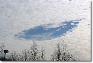
Weather Topic: What are Hole Punch Clouds?
Home - Education - Cloud Types - Hole Punch Clouds
 Next Topic: Mammatus Clouds
A hole punch cloud is an unusual occurrence when a disk-shaped
hole appears in a cirrostratus, cirrocumulus, or altocumulus cloud.
When part of the cloud forms ice crystals, water droplets in the surrounding area
of the cloud evaporate. The effect of this process produces a large elliptical
gap in the cloud. The hole punch cloud formation is rare, but it is not specific
to any geographic area.
Other names which have been used to describe this phenomena include fallstreak hole,
skypunch, and cloud hole.
Next Topic: Mammatus Clouds
Weather Topic: What are Nimbostratus Clouds?
Home - Education - Cloud Types - Nimbostratus Clouds
 Next Topic: Precipitation
A nimbostratus cloud is similar to a stratus cloud in its formless,
smooth appearance. However, a nimbostratus cloud is darker than a stratus cloud,
because it is thicker.
Unlike a stratus cloud, a nimbostratus cloud typically brings with it the threat
of moderate to heavy precipitation. In some cases, the precipitation may evaporate
before reaching the ground, a phenomenon known as virga.
Next Topic: Precipitation
Current conditions powered by WeatherAPI.com


