Weather Alert in Florida
Flood Warning issued August 25 at 10:53AM EDT until August 28 at 2:00PM EDT by NWS Melbourne FL
AREAS AFFECTED: Lake, FL; Volusia, FL
DESCRIPTION: ...The National Weather Service in Melbourne FL has issued a Flood Warning for the following rivers in Florida... St Johns River Near Astor affecting Lake and Volusia Counties. .On the Saint Johns River at Astor, river levels are forecast to reach Minor Flood Stage by Tuesday, due to heavy rainfall the last few days and additional rainfall expected this week. The river is forecast to remain in or near Minor Flood stage through the week. For the St. Johns River...including Astor...Minor flooding is forecast. Additional information is available at www.weather.gov. The next statement will be issued Tuesday morning at 1100 AM EDT. * WHAT...Minor flooding is forecast. * WHERE...St Johns River near Astor. * WHEN...From Tuesday morning to early Thursday afternoon. * IMPACTS...At 2.0 feet, River levels rise and fills canals, encroaching on docks, yards and boat ramps in the vicinity of SR-40. Properties in low areas along and near the river and many canals should prepare for further water encroachment. At 2.3 feet, Many docks become submerged along the river and in canals in the Astor community. Water enters yards of properties on Bartram Road, Holiday Circle and along Wild Hog Road on the Lake County side. In Volusia County, water encroaches yards of homes on the river side of Alice Drive. No wake zones are in effect from near the South Moon Canal to approximately 800 feet south of the Riverview lodge. * ADDITIONAL DETAILS... - At 10:30 AM EDT Monday the stage was 2.2 feet. - Bankfull stage is 2.0 feet. - Forecast...The river is expected to rise to a crest of 2.3 feet tomorrow morning. It will then fall below flood stage Thursday morning. - Flood stage is 2.3 feet. - http://www.weather.gov/safety/flood
INSTRUCTION: N/A
Want more detail? Get the Complete 7 Day and Night Detailed Forecast!
Current U.S. National Radar--Current
The Current National Weather Radar is shown below with a UTC Time (subtract 5 hours from UTC to get Eastern Time).

National Weather Forecast--Current
The Current National Weather Forecast and National Weather Map are shown below.

National Weather Forecast for Tomorrow
Tomorrow National Weather Forecast and Tomorrow National Weather Map are show below.

North America Water Vapor (Moisture)
This map shows recent moisture content over North America. Bright and colored areas show high moisture (ie, clouds); brown indicates very little moisture present; black indicates no moisture.

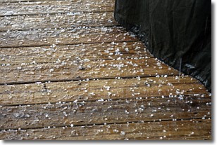
Weather Topic: What is Sleet?
Home - Education - Precipitation - Sleet
 Next Topic: Snow
Sleet is a form of precipitation in which small ice pellets are the primary
components. These ice pellets are smaller and more translucent than hailstones,
and harder than graupel. Sleet is caused by specific atmospheric conditions and
therefore typically doesn't last for extended periods of time.
The condition which leads to sleet formation requires a warmer body of air to be
wedged in between two sub-freezing bodies of air. When snow falls through a warmer
layer of air it melts, and as it falls through the next sub-freezing body of air
it freezes again, forming ice pellets known as sleet. In some cases, water
droplets don't have time to freeze before reaching the surface and the result is
freezing rain.
Next Topic: Snow
Weather Topic: What are Stratocumulus Clouds?
Home - Education - Cloud Types - Stratocumulus Clouds
 Next Topic: Stratus Clouds
Stratocumulus clouds are similar to altocumulus clouds in their
fluffy appearance, but have a slightly darker shade due to their additional mass.
A good way to distinguish the two cloud types is to hold your hand out and measure
the size of an individual cloud; if it is the size of your thumb it is generally
an altocumulus cloud, if it is the size of your hand it is generally a
stratocumulus cloud.
It is uncommon for stratocumulus clouds to produce precipitation, but if they do
it is usually a light rain or snow.
Next Topic: Stratus Clouds
Current conditions powered by WeatherAPI.com


