Weather Alert in Ohio
Special Weather Statement issued February 6 at 9:20PM EST by NWS Pittsburgh PA
AREAS AFFECTED: Tuscarawas; Carroll; Coshocton; Harrison; Jefferson; Muskingum; Guernsey; Belmont; Noble; Monroe; Allegheny; Washington; Greene; Westmoreland; Westmoreland Ridges; Fayette; Fayette Ridges; Indiana; Higher Elevations of Indiana; Hancock; Brooke; Ohio; Marshall; Wetzel; Marion; Monongalia; Ridges of Eastern Monongalia and Northwestern Preston; Preston
DESCRIPTION: A arctic cold front continues to drop across the region this evening. A band of moderate to heavy snow showers is accompanying the boundary. Visibilities of one-half mile or less and wind gusts to 40 MPH are possible in the heavier snow showers. A quick accumulation of one-half to one inch will be possible, especially on untreated surfaces. Snow Squall Warnings are already in effect for portions of this band, and more may be necessary for the heaviest showers that drop visibility to one- quarter mile or less in heavy, blowing snow. Motorists are urged to use caution while driving this evening. If you encounter heavy snow and very low visibility, slow down and increase the distance between your car and those that surround you. Consider delaying travel until the heavy snow showers have passed.
INSTRUCTION: N/A
Want more detail? Get the Complete 7 Day and Night Detailed Forecast!
Current U.S. National Radar--Current
The Current National Weather Radar is shown below with a UTC Time (subtract 5 hours from UTC to get Eastern Time).

National Weather Forecast--Current
The Current National Weather Forecast and National Weather Map are shown below.

National Weather Forecast for Tomorrow
Tomorrow National Weather Forecast and Tomorrow National Weather Map are show below.

North America Water Vapor (Moisture)
This map shows recent moisture content over North America. Bright and colored areas show high moisture (ie, clouds); brown indicates very little moisture present; black indicates no moisture.

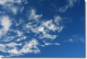
Weather Topic: What are Cirrostratus Clouds?
Home - Education - Cloud Types - Cirrostratus Clouds
 Next Topic: Cirrus Clouds
Cirrostratus clouds are high, thin clouds that form above
20,000 feet and are made mostly of ice crystals. They sometimes look like giant
feathers, horse tails, or curls of hair in the sky.
These clouds are pushed by the jet stream and can move at high speeds reaching
100 mph.
What do they indicate?
They indicate that a precipitation is likely within 24 hours.
Next Topic: Cirrus Clouds
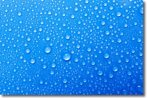
Weather Topic: What is Condensation?
Home - Education - Precipitation - Condensation
 Next Topic: Contrails
Condensation is the process which creates clouds, and therefore
it is a crucial process in the water cycle.
Condensation is the change of matter from a state of gas into a state of liquid,
and it happens because water molecules release heat into the atmosphere and
become organized into a more closely packed structure, what we might see as
water droplets.
Water is always present in the air around us as a vapor, but it's too small for
us to see. When water undergoes the process of condensation it becomes organized
into visible water droplets. You've probably seen condensation happen before on the
surface of a cold drink!
Next Topic: Contrails
Current conditions powered by WeatherAPI.com


