Weather Alert in Oregon
Flash Flood Watch issued August 26 at 12:30PM PDT until August 27 at 5:00AM PDT by NWS Boise ID
AREAS AFFECTED: Harney County
DESCRIPTION: A surge of deep monsoonal moisture combined with a slow-moving upper trough will bring periods of heavy showers and thunderstorms across the region. This airmass contains anomalously high moisture content, supporting the potential for excessive rainfall. Flash flooding will be possible, especially in steep terrain, narrow canyons, and near recent burn scars where soils are less able to absorb rainfall. The greatest risk will be Tuesday afternoon through Wednesday evening as repeated rounds of storms move through. * WHAT...Flash flooding caused by excessive rainfall continues to be possible. * WHERE...A portion of southeast Oregon, including the following county, Harney County. * WHEN...Through late tonight. * IMPACTS...Heavy rainfall could trigger flash flooding or debris flows, especially in and near recent wildfire burn scars. * ADDITIONAL DETAILS... - https://www.weather.gov/safety/flood
INSTRUCTION: You should monitor later forecasts and be prepared to take action should Flash Flood Warnings be issued. Local emergency services are monitoring the situation and will issue a public statement as conditions warrant. PLAN NOW so you will know what to do in an emergency. Keep informed by listening to local radio and television for statements and possible warnings. Follow the advice of public safety officials.
Want more detail? Get the Complete 7 Day and Night Detailed Forecast!
Current U.S. National Radar--Current
The Current National Weather Radar is shown below with a UTC Time (subtract 5 hours from UTC to get Eastern Time).

National Weather Forecast--Current
The Current National Weather Forecast and National Weather Map are shown below.

National Weather Forecast for Tomorrow
Tomorrow National Weather Forecast and Tomorrow National Weather Map are show below.

North America Water Vapor (Moisture)
This map shows recent moisture content over North America. Bright and colored areas show high moisture (ie, clouds); brown indicates very little moisture present; black indicates no moisture.

Weather Topic: What is Graupel?
Home - Education - Precipitation - Graupel
 Next Topic: Hail
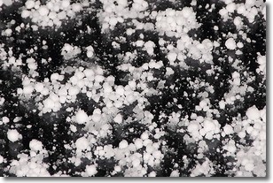
Graupel is a form of precipitation that is created by atmospheric conditions
which cause supercooled water droplets to contact snow crystals and freeze to
their surface.
Sometimes known as soft hail or snow pellets, graupel is delicate and easily
destroyed by touch. Whereas hail usually falls during severe weather, graupel
doesn't require such conditions to form, and can form in mild precipitation
similar to situations which produce snowfall.
Next Topic: Hail
Weather Topic: What are Hole Punch Clouds?
Home - Education - Cloud Types - Hole Punch Clouds
 Next Topic: Mammatus Clouds
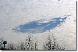
A hole punch cloud is an unusual occurrence when a disk-shaped
hole appears in a cirrostratus, cirrocumulus, or altocumulus cloud.
When part of the cloud forms ice crystals, water droplets in the surrounding area
of the cloud evaporate. The effect of this process produces a large elliptical
gap in the cloud. The hole punch cloud formation is rare, but it is not specific
to any geographic area.
Other names which have been used to describe this phenomena include fallstreak hole,
skypunch, and cloud hole.
Next Topic: Mammatus Clouds
Current conditions powered by WeatherAPI.com


