Weather Alert in Ohio
Special Weather Statement issued February 6 at 8:12PM EST by NWS Pittsburgh PA
AREAS AFFECTED: Columbiana; Mercer; Venango; Forest; Lawrence; Butler; Clarion; Jefferson; Beaver; Armstrong; Indiana; Higher Elevations of Indiana
DESCRIPTION: A arctic cold front will drop across the region during the late evening hours. The front will be accompanied by bands of snow showers, some of which will be moderate to briefly heavy at times. Visibilities of one-half mile or less and wind gusts to 35 MPH are possible in the heavier snow showers. A quick accumulation of one-half to one inch will be possible, especially on untreated surfaces. Snow Squall Warnings may be necessary for the heaviest showers that drop visibility to one- quarter mile or less in heavy, blowing snow. Motorists are urged to use caution while driving this evening. If you encounter heavy snow and very low visibility, slow down and increase the distance between your car and those that surround you. Consider delaying travel until the heavy snow showers have passed.
INSTRUCTION: N/A
Want more detail? Get the Complete 7 Day and Night Detailed Forecast!
Current U.S. National Radar--Current
The Current National Weather Radar is shown below with a UTC Time (subtract 5 hours from UTC to get Eastern Time).

National Weather Forecast--Current
The Current National Weather Forecast and National Weather Map are shown below.

National Weather Forecast for Tomorrow
Tomorrow National Weather Forecast and Tomorrow National Weather Map are show below.

North America Water Vapor (Moisture)
This map shows recent moisture content over North America. Bright and colored areas show high moisture (ie, clouds); brown indicates very little moisture present; black indicates no moisture.

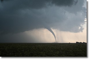
Weather Topic: What are Wall Clouds?
Home - Education - Cloud Types - Wall Clouds
 Next Topic: Altocumulus Clouds
A wall cloud forms underneath the base of a cumulonimbus cloud,
and can be a hotbed for deadly tornadoes.
Wall clouds are formed by air flowing into the cumulonimbus clouds, which can
result in the wall cloud descending from the base of the cumulonimbus cloud, or
rising fractus clouds which join to the base of the storm cloud as the wall cloud
takes shape.
Wall clouds can be very large, and in the Northern Hemisphere they generally
form at the southern edge of cumulonimbus clouds.
Next Topic: Altocumulus Clouds
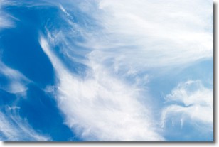
Weather Topic: What are Altostratus Clouds?
Home - Education - Cloud Types - Altostratus Clouds
 Next Topic: Cirrocumulus Clouds
Altostratus clouds form at mid to high-level altitudes
(between 2 and 7 km) and are created by a warm, stable air mass which causes
water vapor
to condense as it rise through the atmosphere. Usually altostratus clouds are
featureless sheets characterized by a uniform color.
In some cases, wind punching through the cloud formation may give it a waved
appearance, called altostratus undulatus. Altostratus clouds
are commonly seen with other cloud formations accompanying them.
Next Topic: Cirrocumulus Clouds
Current conditions powered by WeatherAPI.com


