Weather Alert in California
Flood Warning issued February 25 at 1:50PM PST until February 26 at 5:10PM PST by NWS Sacramento CA
AREAS AFFECTED: Tehama, CA
DESCRIPTION: ...The Flood Warning is extended for the following rivers in California... Sacramento River At Vina Woodson Bridge affecting Tehama County. Sacramento River At Tehama Bridge affecting Tehama County. Sacramento River At Ord Ferry affecting Glenn and Butte Counties. .Recent precipitation has lead to to minor flooding at Ord Ferry, Tehama Bridge and Vina Woodson Bridge on the Upper Sacramento River System. For the Upper Sacramento River...including Tehama Bridge, Vina Woodson Bridge, Ord Ferry...Minor flooding is forecast. * WHAT...Minor flooding is occurring and minor flooding is forecast. * WHERE...Sacramento River at Vina Woodson Bridge. * WHEN...Until tomorrow afternoon. * IMPACTS...At 183.9 feet, Tehama County Park on left bank of river is closed due to flooding. Water is up to the top steps of the recreation center at the RV Park south of the bridge and on left bank of river with spaces 15-33 taking on water. At 184.9 feet, South Avenue starts to flood east of the river. At 185.9 feet, South Avenue is flooded and closed. RV Park south of the bridge and on left bank of river experiences more flooding with RV Park office, spaces 1-14, 34-52, and 62-72 impacted. * ADDITIONAL DETAILS... - At 1:00 PM PST Wednesday the stage was 185.8 feet. - Bankfull stage is 180.0 feet. - Recent Activity...The maximum river stage in the 24 hours ending at 1:00 PM PST Wednesday was 185.8 feet. - Forecast...The river is expected to fall below flood stage just after midnight tonight and continue falling to 171.8 feet early Friday afternoon. - Flood stage is 183.0 feet. - Flood History...This crest compares to a previous crest of 185.8 feet on 03/06/2006. - http://www.weather.gov/safety/flood
INSTRUCTION: Turn around, don't drown when encountering flooded roads. Most flood deaths occur in vehicles. For more hydrologic information and stage definitions refer to the following web site: wrh.noaa.gov/sto/hydro_data.php The next statement will be issued Thursday afternoon at 200 PM PST.
Want more detail? Get the Complete 7 Day and Night Detailed Forecast!
Current U.S. National Radar--Current
The Current National Weather Radar is shown below with a UTC Time (subtract 5 hours from UTC to get Eastern Time).

National Weather Forecast--Current
The Current National Weather Forecast and National Weather Map are shown below.

National Weather Forecast for Tomorrow
Tomorrow National Weather Forecast and Tomorrow National Weather Map are show below.

North America Water Vapor (Moisture)
This map shows recent moisture content over North America. Bright and colored areas show high moisture (ie, clouds); brown indicates very little moisture present; black indicates no moisture.

Weather Topic: What are Altostratus Clouds?
Home - Education - Cloud Types - Altostratus Clouds
 Next Topic: Cirrocumulus Clouds
Altostratus clouds form at mid to high-level altitudes
(between 2 and 7 km) and are created by a warm, stable air mass which causes
water vapor
to condense as it rise through the atmosphere. Usually altostratus clouds are
featureless sheets characterized by a uniform color.
In some cases, wind punching through the cloud formation may give it a waved
appearance, called altostratus undulatus. Altostratus clouds
are commonly seen with other cloud formations accompanying them.
Next Topic: Cirrocumulus Clouds
Weather Topic: What are Cirrostratus Clouds?
Home - Education - Cloud Types - Cirrostratus Clouds
 Next Topic: Cirrus Clouds
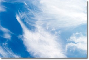
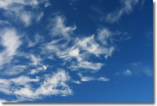
Cirrostratus clouds are high, thin clouds that form above
20,000 feet and are made mostly of ice crystals. They sometimes look like giant
feathers, horse tails, or curls of hair in the sky.
These clouds are pushed by the jet stream and can move at high speeds reaching
100 mph.
What do they indicate?
They indicate that a precipitation is likely within 24 hours.
Next Topic: Cirrus Clouds
Current conditions powered by WeatherAPI.com


