Weather Alert in Idaho
Flash Flood Watch issued August 25 at 12:46PM MDT until August 28 at 12:00AM MDT by NWS Pocatello ID
AREAS AFFECTED: Sawtooth/Stanley Basin
DESCRIPTION: * WHAT...Flash flooding and debris flows caused by excessive rainfall are possible over the Wapiti burn scar. * WHERE...A portion of central Idaho, including the following area, Sawtooth/Stanley Basin. * WHEN...From Tuesday afternoon through Wednesday evening. * IMPACTS...Heavy rainfall over the Wapiti burn scar is expected during the period of the watch. Anyone in or near the Wapiti burn scar should prepare for potential flooding impacts. Be sure to stay up to date with information from local authorities. Heavy rainfall could trigger flash flooding and debris flows in and near recent wildfire burn scars. Heavy rainfall could trigger flash flooding of low-lying areas, urbanized street flooding, and debris flows in and near recent wildfire burn scars. * ADDITIONAL DETAILS... - National Weather Service Meteorologists are forecasting heavy rainfall over the burn scar, which may lead to flash flooding and debris flows. - http://www.weather.gov/safety/flood
INSTRUCTION: You should monitor later forecasts and be prepared to take action should Flash Flood Warnings be issued.
Want more detail? Get the Complete 7 Day and Night Detailed Forecast!
Current U.S. National Radar--Current
The Current National Weather Radar is shown below with a UTC Time (subtract 5 hours from UTC to get Eastern Time).

National Weather Forecast--Current
The Current National Weather Forecast and National Weather Map are shown below.

National Weather Forecast for Tomorrow
Tomorrow National Weather Forecast and Tomorrow National Weather Map are show below.

North America Water Vapor (Moisture)
This map shows recent moisture content over North America. Bright and colored areas show high moisture (ie, clouds); brown indicates very little moisture present; black indicates no moisture.

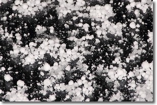
Weather Topic: What is Graupel?
Home - Education - Precipitation - Graupel
 Next Topic: Hail
Graupel is a form of precipitation that is created by atmospheric conditions
which cause supercooled water droplets to contact snow crystals and freeze to
their surface.
Sometimes known as soft hail or snow pellets, graupel is delicate and easily
destroyed by touch. Whereas hail usually falls during severe weather, graupel
doesn't require such conditions to form, and can form in mild precipitation
similar to situations which produce snowfall.
Next Topic: Hail
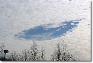
Weather Topic: What are Hole Punch Clouds?
Home - Education - Cloud Types - Hole Punch Clouds
 Next Topic: Mammatus Clouds
A hole punch cloud is an unusual occurrence when a disk-shaped
hole appears in a cirrostratus, cirrocumulus, or altocumulus cloud.
When part of the cloud forms ice crystals, water droplets in the surrounding area
of the cloud evaporate. The effect of this process produces a large elliptical
gap in the cloud. The hole punch cloud formation is rare, but it is not specific
to any geographic area.
Other names which have been used to describe this phenomena include fallstreak hole,
skypunch, and cloud hole.
Next Topic: Mammatus Clouds
Current conditions powered by WeatherAPI.com


