Weather Alert in Pennsylvania
Snow Squall Warning issued February 6 at 8:29PM EST until February 6 at 9:00PM EST by NWS Pittsburgh PA
AREAS AFFECTED: Butler, PA; Clarion, PA; Forest, PA; Lawrence, PA; Mercer, PA; Venango, PA
DESCRIPTION: The National Weather Service in Pittsburgh has issued a * Snow Squall Warning for... Southwestern Forest County in northwestern Pennsylvania... Mercer County in northwestern Pennsylvania... Venango County in northwestern Pennsylvania... Northern Butler County in west central Pennsylvania... Central Clarion County in west central Pennsylvania... Northern Lawrence County in western Pennsylvania... * Until 900 PM EST. * At 829 PM EST, a hazardous snow squall was located along a line from 6 miles west of Tionesta to over Hermitage, or along a line from 8 miles northeast of Oil City to over Hermitage, moving southeast at 45 mph. HAZARD...Intense bursts of heavy snow and gusty winds leading to blowing snow and rapidly falling visibility. Wind gusts up to 35 mph. SOURCE...Radar indicated. IMPACT...Travel will become difficult and potentially hazardous within minutes. * Locations impacted include... Hermitage, Sharon, Oil City, Grove City, Franklin, Sharpsville, Knox, Greenville, Sugarcreek, Farrell, Slippery Rock, New Wilmington, Oakwood, New Castle Northwest, Tionesta, Mercer, Pulaski, Hasson Heights, Stoneboro and Seneca. This includes the following highways... Interstate 80 in Pennsylvania between mile markers 0 and 59. Interstate 79 in Pennsylvania between mile markers 107 and 135. Interstate 376 between mile markers 0 and 12.
INSTRUCTION: Slow Down! Rapid changes in visibility and road conditions are expected with this dangerous snow squall. Be alert for sudden whiteout conditions. Reduce your speed and turn on headlights! During snow squalls, the visibility may suddenly drop to near zero in whiteout conditions.
Want more detail? Get the Complete 7 Day and Night Detailed Forecast!
Current U.S. National Radar--Current
The Current National Weather Radar is shown below with a UTC Time (subtract 5 hours from UTC to get Eastern Time).

National Weather Forecast--Current
The Current National Weather Forecast and National Weather Map are shown below.

National Weather Forecast for Tomorrow
Tomorrow National Weather Forecast and Tomorrow National Weather Map are show below.

North America Water Vapor (Moisture)
This map shows recent moisture content over North America. Bright and colored areas show high moisture (ie, clouds); brown indicates very little moisture present; black indicates no moisture.

Weather Topic: What are Altostratus Clouds?
Home - Education - Cloud Types - Altostratus Clouds
 Next Topic: Cirrocumulus Clouds
Altostratus clouds form at mid to high-level altitudes
(between 2 and 7 km) and are created by a warm, stable air mass which causes
water vapor
to condense as it rise through the atmosphere. Usually altostratus clouds are
featureless sheets characterized by a uniform color.
In some cases, wind punching through the cloud formation may give it a waved
appearance, called altostratus undulatus. Altostratus clouds
are commonly seen with other cloud formations accompanying them.
Next Topic: Cirrocumulus Clouds
Weather Topic: What are Cirrostratus Clouds?
Home - Education - Cloud Types - Cirrostratus Clouds
 Next Topic: Cirrus Clouds
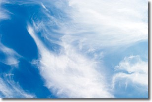
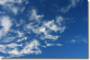
Cirrostratus clouds are high, thin clouds that form above
20,000 feet and are made mostly of ice crystals. They sometimes look like giant
feathers, horse tails, or curls of hair in the sky.
These clouds are pushed by the jet stream and can move at high speeds reaching
100 mph.
What do they indicate?
They indicate that a precipitation is likely within 24 hours.
Next Topic: Cirrus Clouds
Current conditions powered by WeatherAPI.com


