Weather Alert in Alaska
Blizzard Warning issued February 26 at 4:56AM AKST until February 26 at 3:00PM AKST by NWS Anchorage AK
AREAS AFFECTED: Northern Copper Valley
DESCRIPTION: * WHAT...Blizzard conditions. Winds gusting as high as 45 mph. Significant blowing and drifting snow is occurring. * WHERE...Along the Richardson Highway from milemarker 148 north to Paxson through Isabel Pass. * WHEN...Until 3 PM AKST this afternoon. * IMPACTS...Whiteout conditions are ongoing and will make travel treacherous, and potentially life-threatening. Travel will be impacted. Areas of blowing snow could significantly reduce visibility. * ADDITIONAL DETAILS...Alaska 511 has closed a section of the Richardson Highway from Paxson to milemarker 218. Hazardous conditions are expected south of this area from milemarker 148 to Paxson and north.
INSTRUCTION: A Blizzard Warning means severe winter weather conditions are expected or occurring. Falling and blowing snow with strong winds and poor visibilities are likely. This will lead to whiteout conditions, making travel very hazardous. If you must travel, have a winter survival kit with you. If you get stranded, stay with your vehicle. For the latest road conditions call 5 1 1 or visit 511.alaska.gov.
Want more detail? Get the Complete 7 Day and Night Detailed Forecast!
Current U.S. National Radar--Current
The Current National Weather Radar is shown below with a UTC Time (subtract 5 hours from UTC to get Eastern Time).

National Weather Forecast--Current
The Current National Weather Forecast and National Weather Map are shown below.

National Weather Forecast for Tomorrow
Tomorrow National Weather Forecast and Tomorrow National Weather Map are show below.

North America Water Vapor (Moisture)
This map shows recent moisture content over North America. Bright and colored areas show high moisture (ie, clouds); brown indicates very little moisture present; black indicates no moisture.

Weather Topic: What is Sleet?
Home - Education - Precipitation - Sleet
 Next Topic: Snow
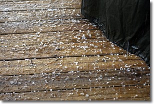
Sleet is a form of precipitation in which small ice pellets are the primary
components. These ice pellets are smaller and more translucent than hailstones,
and harder than graupel. Sleet is caused by specific atmospheric conditions and
therefore typically doesn't last for extended periods of time.
The condition which leads to sleet formation requires a warmer body of air to be
wedged in between two sub-freezing bodies of air. When snow falls through a warmer
layer of air it melts, and as it falls through the next sub-freezing body of air
it freezes again, forming ice pellets known as sleet. In some cases, water
droplets don't have time to freeze before reaching the surface and the result is
freezing rain.
Next Topic: Snow
Weather Topic: What are Stratocumulus Clouds?
Home - Education - Cloud Types - Stratocumulus Clouds
 Next Topic: Stratus Clouds
Stratocumulus clouds are similar to altocumulus clouds in their
fluffy appearance, but have a slightly darker shade due to their additional mass.
A good way to distinguish the two cloud types is to hold your hand out and measure
the size of an individual cloud; if it is the size of your thumb it is generally
an altocumulus cloud, if it is the size of your hand it is generally a
stratocumulus cloud.
It is uncommon for stratocumulus clouds to produce precipitation, but if they do
it is usually a light rain or snow.
Next Topic: Stratus Clouds
Current conditions powered by WeatherAPI.com


