Weather Alert in Ohio
Special Weather Statement issued February 6 at 7:20PM EST by NWS Pittsburgh PA
AREAS AFFECTED: Tuscarawas; Carroll; Columbiana; Coshocton; Harrison; Jefferson; Muskingum; Guernsey; Belmont; Noble; Monroe; Beaver; Allegheny; Washington; Greene; Hancock; Brooke; Ohio; Marshall; Wetzel; Marion; Monongalia
DESCRIPTION: Some areas of freezing drizzle are possible this evening, mixed at times with snow. The freezing drizzle may create a thin layer of icing on exposed surfaces and untreated roads. The risk of freezing drizzle is expected to end later this evening with the arrival of an arctic cold front. This front is forecast to bring bands of moderate to heavy snow showers, along with northwest wind gusts of 25 to 35 MPH. The snow showers may reduce visibility to a half-mile or less for brief periods and cause quick accumulation on untreated roads. Motorists are urged to use caution while driving this evening. Reduce speed and increase the distance between your vehicle and those that surround you.
INSTRUCTION: N/A
Want more detail? Get the Complete 7 Day and Night Detailed Forecast!
Current U.S. National Radar--Current
The Current National Weather Radar is shown below with a UTC Time (subtract 5 hours from UTC to get Eastern Time).

National Weather Forecast--Current
The Current National Weather Forecast and National Weather Map are shown below.

National Weather Forecast for Tomorrow
Tomorrow National Weather Forecast and Tomorrow National Weather Map are show below.

North America Water Vapor (Moisture)
This map shows recent moisture content over North America. Bright and colored areas show high moisture (ie, clouds); brown indicates very little moisture present; black indicates no moisture.

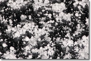
Weather Topic: What is Graupel?
Home - Education - Precipitation - Graupel
 Next Topic: Hail
Graupel is a form of precipitation that is created by atmospheric conditions
which cause supercooled water droplets to contact snow crystals and freeze to
their surface.
Sometimes known as soft hail or snow pellets, graupel is delicate and easily
destroyed by touch. Whereas hail usually falls during severe weather, graupel
doesn't require such conditions to form, and can form in mild precipitation
similar to situations which produce snowfall.
Next Topic: Hail
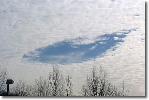
Weather Topic: What are Hole Punch Clouds?
Home - Education - Cloud Types - Hole Punch Clouds
 Next Topic: Mammatus Clouds
A hole punch cloud is an unusual occurrence when a disk-shaped
hole appears in a cirrostratus, cirrocumulus, or altocumulus cloud.
When part of the cloud forms ice crystals, water droplets in the surrounding area
of the cloud evaporate. The effect of this process produces a large elliptical
gap in the cloud. The hole punch cloud formation is rare, but it is not specific
to any geographic area.
Other names which have been used to describe this phenomena include fallstreak hole,
skypunch, and cloud hole.
Next Topic: Mammatus Clouds
Current conditions powered by WeatherAPI.com


