Weather Alert in Connecticut
Special Weather Statement issued September 6 at 4:19AM EDT by NWS Boston/Norton MA
AREAS AFFECTED: Hartford; Tolland; Windham; Western Franklin; Eastern Franklin; Northern Worcester; Western Hampshire; Western Hampden; Eastern Hampshire; Eastern Hampden; Southern Worcester; Northwest Middlesex County
DESCRIPTION: A cold front brings potential for scattered severe thunderstorms today to interior southern New England. Thunderstorms may begin to pop-up across eastern New York, along the border with Connecticut and Massachusetts early as 12-2pm. There after is prime time for storms to build develop,between 2-6pm, across the interior of southern New England. Expect thunderstorms to weaken as the line shifts to the I-95 corridor between 7-10pm. Thunderstorms will have the potential to produce straight-line damaging winds, hail, localized flash flooding in urban areas or locations of poor drainage, frequent lightning, and a lower risk of tornadoes. Whether you are heading to an outdoor event or hanging around the house, today is one of those days to remain weather aware, and have multiple ways of receiving weather alerts (cell phone notifications, NOAA Weather Radio, and broadcast meteorologists).
INSTRUCTION: N/A
Want more detail? Get the Complete 7 Day and Night Detailed Forecast!
Current U.S. National Radar--Current
The Current National Weather Radar is shown below with a UTC Time (subtract 5 hours from UTC to get Eastern Time).

National Weather Forecast--Current
The Current National Weather Forecast and National Weather Map are shown below.

National Weather Forecast for Tomorrow
Tomorrow National Weather Forecast and Tomorrow National Weather Map are show below.

North America Water Vapor (Moisture)
This map shows recent moisture content over North America. Bright and colored areas show high moisture (ie, clouds); brown indicates very little moisture present; black indicates no moisture.

Weather Topic: What are Fractus Clouds?
Home - Education - Cloud Types - Fractus Clouds
 Next Topic: Freezing Rain
A fractus cloud (scud) is a fragmented, tattered cloud which has
likely been sheared off of another cloud. They are accessory clouds, meaning they
develop from parent clouds, and are named in a way which describes the original
cloud which contained them.
Fractus clouds which have originated from cumulus clouds are referred to as
cumulus fractus, while fractus clouds which have originated from stratus clouds
are referred to as stratus fractus. Under certain conditions a fractus cloud might
merge with another cloud, or develop into a cumulus cloud, but usually a
fractus cloud seen by itself will dissipate rapidly.
They are often observed on the leading and trailing edges of storm clouds,
and are a display of wind activity.
Next Topic: Freezing Rain
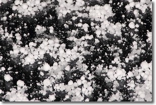
Weather Topic: What is Graupel?
Home - Education - Precipitation - Graupel
 Next Topic: Hail
Graupel is a form of precipitation that is created by atmospheric conditions
which cause supercooled water droplets to contact snow crystals and freeze to
their surface.
Sometimes known as soft hail or snow pellets, graupel is delicate and easily
destroyed by touch. Whereas hail usually falls during severe weather, graupel
doesn't require such conditions to form, and can form in mild precipitation
similar to situations which produce snowfall.
Next Topic: Hail
Current conditions powered by WeatherAPI.com


