Weather Alert in Minnesota
Flood Warning issued July 9 at 8:42PM CDT until July 14 at 1:00AM CDT by NWS Twin Cities/Chanhassen MN
AREAS AFFECTED: Blue Earth, MN; Brown, MN; Nicollet, MN
DESCRIPTION: ...The Flood Warning continues for the following rivers in Minnesota... Minnesota River at Granite Falls HWY 212 affecting Chippewa, Yellow Medicine and Renville Counties. Minnesota River near Jordan affecting Carver, Scott and Sibley Counties. Minnesota River at New Ulm affecting Nicollet, Blue Earth and Brown Counties. Minnesota River at Morton affecting Renville and Redwood Counties. Minnesota River at Montevideo affecting Lac qui Parle, Chippewa and Yellow Medicine Counties. * WHAT...Minor flooding is occurring and forecast to continue. * WHERE...Minnesota River at New Ulm. * WHEN...Until late Sunday night. * IMPACTS...At 801.0 feet, Flood gate at 18th South Street is closed. * ADDITIONAL DETAILS... - At 645 PM CDT Wednesday, the stage was 800.9 feet. - Recent Activity...The maximum river stage in the 24 hours ending at 645 PM CDT Wednesday was 801.0 feet. - Forecast...The river is expected to fall below flood stage Sunday morning and continue falling to 798.8 feet Wednesday, July 16. - Flood stage is 800.0 feet. - Flood History...This crest compares to a previous crest of 801.4 feet on 04/26/2018.
INSTRUCTION: Turn around, don't drown when encountering flooded roads. Most flood deaths occur in vehicles. Caution is urged when walking near riverbanks.
Want more detail? Get the Complete 7 Day and Night Detailed Forecast!
Current U.S. National Radar--Current
The Current National Weather Radar is shown below with a UTC Time (subtract 5 hours from UTC to get Eastern Time).

National Weather Forecast--Current
The Current National Weather Forecast and National Weather Map are shown below.

National Weather Forecast for Tomorrow
Tomorrow National Weather Forecast and Tomorrow National Weather Map are show below.

North America Water Vapor (Moisture)
This map shows recent moisture content over North America. Bright and colored areas show high moisture (ie, clouds); brown indicates very little moisture present; black indicates no moisture.

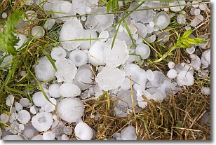
Weather Topic: What is Hail?
Home - Education - Precipitation - Hail
 Next Topic: Hole Punch Clouds
Hail is a form of precipitation which is recognized by large solid balls or
clumps of ice. Hail is created by thunderstorm clouds with strong updrafts of wind.
As the hailstones remain in the updraft, ice is deposited onto them until their
weight becomes heavy enough for them to fall to the earth's surface.
Hail storms can cause significant damage to crops, aircrafts, and man-made structures,
despite the fact that the duration is usually less than ten minutes.
Next Topic: Hole Punch Clouds
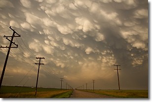
Weather Topic: What are Mammatus Clouds?
Home - Education - Cloud Types - Mammatus Clouds
 Next Topic: Nimbostratus Clouds
A mammatus cloud is a cloud with a unique feature which resembles
a web of pouches hanging along the base of the cloud.
In the United States, mammatus clouds tend to form in the warmer months, commonly
in the Midwest and eastern regions.
While they usually form at the bottom of a cumulonimbis cloud, they can also form
under altostratus, altocumulus, stratocumulus, and cirrus clouds. Mammatus clouds
warn that severe weather is close.
Next Topic: Nimbostratus Clouds
Current conditions powered by WeatherAPI.com


