Weather Alert in Alaska
Special Weather Statement issued September 7 at 2:50PM AKDT by NWS Juneau AK
AREAS AFFECTED: City and Borough of Yakutat; Municipality of Skagway; Haines Borough and Klukwan; Glacier Bay; Eastern Chichagof Island; Cape Fairweather to Lisianski Strait; City and Borough of Sitka; Admiralty Island; City and Borough of Juneau; Petersburg Borough; Western Kupreanof and Kuiu Island; Prince of Wales Island; City and Borough of Wrangell; Ketchikan Gateway Borough; Annette Island
DESCRIPTION: A WET FALL STORM WILL BE IMPACTING THE PANHANDLE EARLY WEDNESDAY INTO THURSDAY NIGHT DROPPING AROUND 2 TO 4 INCHES OF RAIN FOR THE LOWER ELEVATIONS AND UP TO 6 INCHES FOR THE HIGHER ELEVATIONS OF THE PANHANDLE. FREEZING LEVELS ARE STILL HIGH AROUND 8000 TO 9000 FT ACROSS THE AREA SO MOST OF THE PRECIPITATION THAT FALLS AT ELEVATION WILL BE RAIN. AREA RIVERS AND STREAMS ARE EXPECTED TO EXPERIENCE RISES IN WATER LEVELS AND INCREASED FLOWS WEDNESDAY INTO THURSDAY IN RESPONSE TO THE HEAVIER RAINFALL, AND MAY STAY HIGH INTO FRIDAY. STAY TUNED FOR MORE UPDATES AS WE GET CLOSER TO THE EVENT.
INSTRUCTION: N/A
Want more detail? Get the Complete 7 Day and Night Detailed Forecast!
Current U.S. National Radar--Current
The Current National Weather Radar is shown below with a UTC Time (subtract 5 hours from UTC to get Eastern Time).

National Weather Forecast--Current
The Current National Weather Forecast and National Weather Map are shown below.

National Weather Forecast for Tomorrow
Tomorrow National Weather Forecast and Tomorrow National Weather Map are show below.

North America Water Vapor (Moisture)
This map shows recent moisture content over North America. Bright and colored areas show high moisture (ie, clouds); brown indicates very little moisture present; black indicates no moisture.

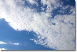
Weather Topic: What are Stratus Clouds?
Home - Education - Cloud Types - Stratus Clouds
 Next Topic: Wall Clouds
Stratus clouds are similar to altostratus clouds, but form at a
lower altitude and are identified by their fog-like appearance, lacking the
distinguishing features of most clouds.
Stratus clouds are wider than most clouds, and their base has a smooth, uniform
look which is lighter in color than a nimbostratus cloud.
The presence of a stratus cloud indicates the possibility of minor precipitation,
such as drizzle, but heavier precipitation does not typically arrive in the form
of a stratus cloud.
Next Topic: Wall Clouds
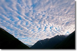
Weather Topic: What are Altocumulus Clouds?
Home - Education - Cloud Types - Altocumulus Clouds
 Next Topic: Altostratus Clouds
Similar to cirrocumulus clouds, altocumulus clouds are
characterized by cloud patches. They are distinguished by larger cloudlets
than cirrocumulus clouds but are still smaller than stratocumulus clouds.
Altocumulus clouds most commonly form in middle altitudes (between 2 and 5 km)
and may resemble, at times, the shape of a flying saucer.
These uncommon formations, called altocumulus lenticularis, are created by uplift
in the atmosphere and are most often seen in close proximity to mountains.
Next Topic: Altostratus Clouds
Current conditions powered by WeatherAPI.com


