Weather Alert in California
Heat Advisory issued July 9 at 1:49PM PDT until July 13 at 11:00PM PDT by NWS Sacramento CA
AREAS AFFECTED: Shasta Lake Area / Northern Shasta County; Burney Basin / Eastern Shasta County; Northern Sacramento Valley; Central Sacramento Valley; Mountains Southwestern Shasta County to Western Colusa County; Northeast Foothills/Sacramento Valley; Western Plumas County/Lassen Park
DESCRIPTION: * WHAT...High temperatures up to 95 to 110 expected. Overnight low temperatures in the upper 60s to around 80. Widespread Moderate HeatRisk with areas of Major HeatRisk. * WHERE...Burney Basin, Northern and Central Sacramento Valley, Mountains Southwestern Shasta County to Western Colusa County, Northeast Foothills, Shasta Lake Area / Northern Shasta County, and Western Plumas County/Lassen Park. * WHEN...From 11 AM Friday to 11 PM PDT Sunday. * IMPACTS...Heat related illnesses increase significantly during heat events, particularly for those working or participating in outdoor activities.
INSTRUCTION: Drink plenty of fluids, stay in an air-conditioned room, stay out of the sun, and check up on relatives and neighbors, especially those more susceptible to heat impacts.
Want more detail? Get the Complete 7 Day and Night Detailed Forecast!
Current U.S. National Radar--Current
The Current National Weather Radar is shown below with a UTC Time (subtract 5 hours from UTC to get Eastern Time).

National Weather Forecast--Current
The Current National Weather Forecast and National Weather Map are shown below.

National Weather Forecast for Tomorrow
Tomorrow National Weather Forecast and Tomorrow National Weather Map are show below.

North America Water Vapor (Moisture)
This map shows recent moisture content over North America. Bright and colored areas show high moisture (ie, clouds); brown indicates very little moisture present; black indicates no moisture.

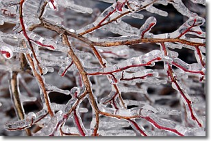
Weather Topic: What is Freezing Rain?
Home - Education - Precipitation - Freezing Rain
 Next Topic: Graupel
Freezing rain is a condition where precipitation which has fallen in the form of
water droplets reaches temperatures which are below freezing and freezes upon
coming into contact
with surface objects. The result of this precipitation is a glaze of ice which
can be damaging to plants and man-made structures. A severe onset of freezing
rain which results in a very thick glaze of ice is known as an ice storm.
Next Topic: Graupel
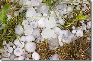
Weather Topic: What is Hail?
Home - Education - Precipitation - Hail
 Next Topic: Hole Punch Clouds
Hail is a form of precipitation which is recognized by large solid balls or
clumps of ice. Hail is created by thunderstorm clouds with strong updrafts of wind.
As the hailstones remain in the updraft, ice is deposited onto them until their
weight becomes heavy enough for them to fall to the earth's surface.
Hail storms can cause significant damage to crops, aircrafts, and man-made structures,
despite the fact that the duration is usually less than ten minutes.
Next Topic: Hole Punch Clouds
Current conditions powered by WeatherAPI.com


