Weather Alert in Washington
Red Flag Warning issued September 5 at 8:53PM PDT until September 7 at 3:00AM PDT by NWS Spokane WA
AREAS AFFECTED: East Washington Central Cascades; Central Washington Cascade Foothills; Waterville Plateau; Western Columbia Basin
DESCRIPTION: ...SCATTERED THUNDERSTORMS SATURDAY AFTERNOON INTO SATURDAY NIGHT... .Scattered thunderstorms will develop in the Cascades starting Saturday afternoon and expand into the western Columbia Basin during the evening and overnight hours with potential for abundant lightning. Storms will also be capable of gusty outflow winds of 30 to 40 mph. The National Weather Service in Spokane has issued a Red Flag Warning for thunderstorms, which is in effect from 4 PM Saturday to 3 AM PDT Sunday. * Affected Area: East Washington Central Cascades (Zone 696), Foothills of Central Washington Cascades (Zone 705), Waterville Plateau (Zone 706) and Western Columbia Basin (Zone 707). * Thunderstorms: Scattered thunderstorms with rainfall amounts between a trace and 0.15" * Outflow Winds: Gusty and erratic outflow winds of 30 to 40 mph. * Impacts: New fire starts are likely with thunderstorms. Gusty outflow winds may lead to fire spread with new or existing fires.
INSTRUCTION: A Red Flag Warning means that critical fire weather conditions are either occurring now....or will shortly. A combination of strong winds...low relative humidity...and warm temperatures can contribute to extreme fire behavior.
Want more detail? Get the Complete 7 Day and Night Detailed Forecast!
Current U.S. National Radar--Current
The Current National Weather Radar is shown below with a UTC Time (subtract 5 hours from UTC to get Eastern Time).

National Weather Forecast--Current
The Current National Weather Forecast and National Weather Map are shown below.

National Weather Forecast for Tomorrow
Tomorrow National Weather Forecast and Tomorrow National Weather Map are show below.

North America Water Vapor (Moisture)
This map shows recent moisture content over North America. Bright and colored areas show high moisture (ie, clouds); brown indicates very little moisture present; black indicates no moisture.

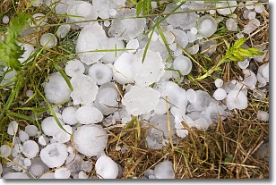
Weather Topic: What is Hail?
Home - Education - Precipitation - Hail
 Next Topic: Hole Punch Clouds
Hail is a form of precipitation which is recognized by large solid balls or
clumps of ice. Hail is created by thunderstorm clouds with strong updrafts of wind.
As the hailstones remain in the updraft, ice is deposited onto them until their
weight becomes heavy enough for them to fall to the earth's surface.
Hail storms can cause significant damage to crops, aircrafts, and man-made structures,
despite the fact that the duration is usually less than ten minutes.
Next Topic: Hole Punch Clouds
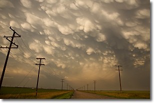
Weather Topic: What are Mammatus Clouds?
Home - Education - Cloud Types - Mammatus Clouds
 Next Topic: Nimbostratus Clouds
A mammatus cloud is a cloud with a unique feature which resembles
a web of pouches hanging along the base of the cloud.
In the United States, mammatus clouds tend to form in the warmer months, commonly
in the Midwest and eastern regions.
While they usually form at the bottom of a cumulonimbis cloud, they can also form
under altostratus, altocumulus, stratocumulus, and cirrus clouds. Mammatus clouds
warn that severe weather is close.
Next Topic: Nimbostratus Clouds
Current conditions powered by WeatherAPI.com


