Weather Alert in New York
Winter Weather Advisory issued February 6 at 1:33PM EST until February 7 at 7:00PM EST by NWS Buffalo NY
AREAS AFFECTED: Niagara; Orleans; Northern Erie; Genesee; Wyoming; Chautauqua; Cattaraugus; Southern Erie
DESCRIPTION: * WHAT...A combination of widespread snow and localized lake effect snow. Additional snow accumulations 2 to 5 inches expected, with locally higher amounts possible across the hilltops south of Buffalo and across Orleans County. Lower-end amounts expected from the city of Buffalo to Niagara Falls. Winds gusting as high as 40 mph will create areas of blowing and drifting snow with poor visibilities at times. * WHERE...Erie, Niagara, Orleans, Genesee, Wyoming, Chautauqua, and Cattaraugus Counties. * WHEN...Until 7 PM EST Saturday. * IMPACTS...Plan on slippery road conditions and reduced visibilities. * ADDITIONAL DETAILS...A warm front will bring widespread light snow showers through the afternoon, which will intensify tonight as an Arctic front moves through. Snow showers then taper off to more localized lake effect snow late tonight through Saturday.
INSTRUCTION: Periods of snow will result in snow covered roads and limited visibilities. Slow down and use caution while driving. Submit snow reports through our website or social media.
Want more detail? Get the Complete 7 Day and Night Detailed Forecast!
Current U.S. National Radar--Current
The Current National Weather Radar is shown below with a UTC Time (subtract 5 hours from UTC to get Eastern Time).

National Weather Forecast--Current
The Current National Weather Forecast and National Weather Map are shown below.

National Weather Forecast for Tomorrow
Tomorrow National Weather Forecast and Tomorrow National Weather Map are show below.

North America Water Vapor (Moisture)
This map shows recent moisture content over North America. Bright and colored areas show high moisture (ie, clouds); brown indicates very little moisture present; black indicates no moisture.

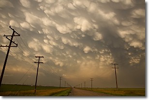
Weather Topic: What are Mammatus Clouds?
Home - Education - Cloud Types - Mammatus Clouds
 Next Topic: Nimbostratus Clouds
A mammatus cloud is a cloud with a unique feature which resembles
a web of pouches hanging along the base of the cloud.
In the United States, mammatus clouds tend to form in the warmer months, commonly
in the Midwest and eastern regions.
While they usually form at the bottom of a cumulonimbis cloud, they can also form
under altostratus, altocumulus, stratocumulus, and cirrus clouds. Mammatus clouds
warn that severe weather is close.
Next Topic: Nimbostratus Clouds
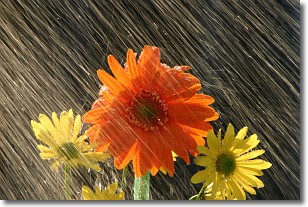
Weather Topic: What is Precipitation?
Home - Education - Precipitation - Precipitation
 Next Topic: Rain
Precipitation can refer to many different forms of water that
may fall from clouds. Precipitation occurs after a cloud has become saturated to
the point where its water particles are more dense than the air below the cloud.
In most cases, precipitation will reach the ground, but it is not uncommon for
precipitation to evaporate before it reaches the earth's surface.
When precipitation evaporates before it contacts the ground it is called Virga.
Graupel, hail, sleet, rain, drizzle, and snow are forms of precipitation, but fog
and mist are not considered precipitation because the water vapor which
constitutes them isn't dense enough to fall to the ground.
Next Topic: Rain
Current conditions powered by WeatherAPI.com


