Weather Alert in Illinois
Air Quality Alert issued September 12 at 3:10PM CDT by NWS St Louis MO
AREAS AFFECTED: Madison; St. Clair; Monroe; St. Charles; Franklin; St. Louis; St. Louis City; Jefferson
DESCRIPTION: The St. Louis Clean Air Partnership has issued an air quality alert for the St. Louis metropolitan area from 10 AM to 8 PM CDT Saturday. An Orange air quality forecast means that maximum ozone concentrations are expected to reach levels that pose a health risk. Adverse health effects increase as air quality deteriorates. Ground- level ozone is an air contaminant which can cause breathing difficulties for children, older adults, as well as persons with respiratory problems. Reducing outdoor physical activity is recommended. If it is a regularly scheduled work day you are urged to consider telecommuting, carpooling, or utilizing public transit. Avoid excessive idling and do not top off when refueling motor vehicles. The use of gasoline-powered lawn equipment should be reduced or postponed until late in the day. For more information visit the St. Louis Clean Air Partnership at http://cleanair-stlouis.com/ For current Air Quality Index (AQI) values visit https://www.airnow.gov/
INSTRUCTION: N/A
Want more detail? Get the Complete 7 Day and Night Detailed Forecast!
Current U.S. National Radar--Current
The Current National Weather Radar is shown below with a UTC Time (subtract 5 hours from UTC to get Eastern Time).

National Weather Forecast--Current
The Current National Weather Forecast and National Weather Map are shown below.

National Weather Forecast for Tomorrow
Tomorrow National Weather Forecast and Tomorrow National Weather Map are show below.

North America Water Vapor (Moisture)
This map shows recent moisture content over North America. Bright and colored areas show high moisture (ie, clouds); brown indicates very little moisture present; black indicates no moisture.

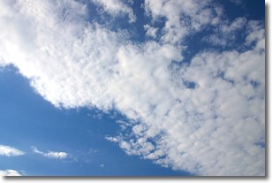
Weather Topic: What are Stratus Clouds?
Home - Education - Cloud Types - Stratus Clouds
 Next Topic: Wall Clouds
Stratus clouds are similar to altostratus clouds, but form at a
lower altitude and are identified by their fog-like appearance, lacking the
distinguishing features of most clouds.
Stratus clouds are wider than most clouds, and their base has a smooth, uniform
look which is lighter in color than a nimbostratus cloud.
The presence of a stratus cloud indicates the possibility of minor precipitation,
such as drizzle, but heavier precipitation does not typically arrive in the form
of a stratus cloud.
Next Topic: Wall Clouds
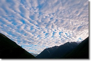
Weather Topic: What are Altocumulus Clouds?
Home - Education - Cloud Types - Altocumulus Clouds
 Next Topic: Altostratus Clouds
Similar to cirrocumulus clouds, altocumulus clouds are
characterized by cloud patches. They are distinguished by larger cloudlets
than cirrocumulus clouds but are still smaller than stratocumulus clouds.
Altocumulus clouds most commonly form in middle altitudes (between 2 and 5 km)
and may resemble, at times, the shape of a flying saucer.
These uncommon formations, called altocumulus lenticularis, are created by uplift
in the atmosphere and are most often seen in close proximity to mountains.
Next Topic: Altostratus Clouds
Current conditions powered by WeatherAPI.com


