Weather Alert in District of Columbia
Severe Thunderstorm Watch issued July 9 at 2:03PM EDT until July 9 at 10:00PM EDT by NWS Baltimore MD/Washington DC
AREAS AFFECTED: District of Columbia, DC; Allegany, MD; Anne Arundel, MD; Baltimore, MD; Calvert, MD; Carroll, MD; Cecil, MD; Charles, MD; Frederick, MD; Garrett, MD; Harford, MD; Howard, MD; Montgomery, MD; Prince Georges, MD; St. Marys, MD; Washington, MD; Baltimore City, MD; Albemarle, VA; Arlington, VA; Augusta, VA; Clarke, VA; Culpeper, VA; Fairfax, VA; Fauquier, VA; Frederick, VA; Greene, VA; Highland, VA; King George, VA; Loudoun, VA; Madison, VA; Nelson, VA; Orange, VA; Page, VA; Prince William, VA; Rappahannock, VA; Rockingham, VA; Shenandoah, VA; Spotsylvania, VA; Stafford, VA; Warren, VA; City of Alexandria, VA; City of Charlottesville, VA; City of Fairfax, VA; City of Falls Church, VA; City of Fredericksburg, VA; City of Harrisonburg, VA; City of Manassas, VA; City of Manassas Park, VA; City of Staunton, VA; City of Waynesboro, VA; City of Winchester, VA; Berkeley, WV; Grant, WV; Hampshire, WV; Hardy, WV; Jefferson, WV; Mineral, WV; Morgan, WV; Pendleton, WV
DESCRIPTION: THE NATIONAL WEATHER SERVICE HAS ISSUED SEVERE THUNDERSTORM WATCH 497 IN EFFECT UNTIL 10 PM EDT THIS EVENING FOR THE FOLLOWING AREAS THE DISTRICT OF COLUMBIA IN MARYLAND THIS WATCH INCLUDES 16 COUNTIES IN CENTRAL MARYLAND ANNE ARUNDEL HOWARD MONTGOMERY PRINCE GEORGES IN NORTH CENTRAL MARYLAND CARROLL FREDERICK WASHINGTON IN NORTHEAST MARYLAND CECIL IN NORTHERN MARYLAND BALTIMORE BALTIMORE CITY HARFORD IN SOUTHERN MARYLAND CALVERT CHARLES ST. MARYS IN WESTERN MARYLAND ALLEGANY GARRETT IN VIRGINIA THIS WATCH INCLUDES 34 COUNTIES IN CENTRAL VIRGINIA ALBEMARLE CITY OF CHARLOTTESVILLE CITY OF FREDERICKSBURG GREENE KING GEORGE NELSON ORANGE SPOTSYLVANIA IN NORTHERN VIRGINIA ARLINGTON CITY OF ALEXANDRIA CITY OF FAIRFAX CITY OF FALLS CHURCH CITY OF MANASSAS CITY OF MANASSAS PARK CULPEPER FAIRFAX FAUQUIER LOUDOUN PRINCE WILLIAM STAFFORD IN NORTHWEST VIRGINIA CITY OF WINCHESTER CLARKE FREDERICK MADISON PAGE RAPPAHANNOCK SHENANDOAH WARREN IN WESTERN VIRGINIA AUGUSTA CITY OF HARRISONBURG CITY OF STAUNTON CITY OF WAYNESBORO HIGHLAND ROCKINGHAM IN WEST VIRGINIA THIS WATCH INCLUDES 8 COUNTIES IN EASTERN WEST VIRGINIA GRANT HAMPSHIRE HARDY MINERAL PENDLETON IN PANHANDLE WEST VIRGINIA BERKELEY JEFFERSON MORGAN THIS INCLUDES THE CITIES OF ABERDEEN, ALEXANDRIA, ANNAPOLIS, ARLINGTON, ARNOLD, ASPEN HILL, BALLENGER CREEK, BALTIMORE, BEL AIR, BERRYVILLE, BETHESDA, BOWIE, CALIFORNIA, CAMP SPRINGS, CATONSVILLE, CHANTILLY, CHARLES TOWN, CHARLOTTESVILLE, CHESAPEAKE BEACH, CLINTON, COLLEGE PARK, COLUMBIA, CROZET, CULPEPER, CUMBERLAND, DAHLGREN, DUNDALK, DUNKIRK, EDGEWOOD, ELDERSBURG, ELKTON, ELLICOTT CITY, ESSEX, FAIRFAX, FALLS CHURCH, FALLSTON, FALMOUTH, FORT ASHBY, FRANKLIN, FREDERICK, FREDERICKSBURG, FRONT ROYAL, FROSTBURG, GAITHERSBURG, GERMANTOWN, GLEN BURNIE, GORDONSVILLE, GRANTSVILLE, GREENBELT, GREENFIELD, HAGERSTOWN, HARRISONBURG, HARRISONBURG, HAVRE DE GRACE, HERNDON, HUNTINGTOWN, JOPPATOWNE, KEYSER, LAUREL, LEESBURG, LEXINGTON PARK, LURAY, LUSBY, MADISON, MANASSAS, MANASSAS PARK, MARTINSBURG, MCLEAN, MONTEREY, MOOREFIELD, MOUNTAIN LAKE PARK, NORTH BEACH, OAKLAND, ODENTON, ORANGE, PARKVILLE, PAW PAW, PETERSBURG, PIKESVILLE, POTOMAC, PRINCE FREDERICK, RANDALLSTOWN, RESTON, ROCKVILLE, ROMNEY, SEVERN, SEVERNA PARK, SHENANDOAH, SHEPHERDSTOWN, SILVER SPRING, SOUTH GATE, SPOTSYLVANIA COURTHOUSE, ST. CHARLES, STANARDSVILLE, STANLEY, STAUNTON, STAUNTON, STERLING, STRASBURG, SUITLAND-SILVER HILL, TOWSON, WALDORF, WARRENTON, WASHINGTON, WASHINGTON, WAYNESBORO, WAYNESBORO, WESTMINSTER, WINCHESTER, WINCHESTER, WOODBRIDGE, AND WOODSTOCK.
INSTRUCTION: N/A
Want more detail? Get the Complete 7 Day and Night Detailed Forecast!
Current U.S. National Radar--Current
The Current National Weather Radar is shown below with a UTC Time (subtract 5 hours from UTC to get Eastern Time).

National Weather Forecast--Current
The Current National Weather Forecast and National Weather Map are shown below.

National Weather Forecast for Tomorrow
Tomorrow National Weather Forecast and Tomorrow National Weather Map are show below.

North America Water Vapor (Moisture)
This map shows recent moisture content over North America. Bright and colored areas show high moisture (ie, clouds); brown indicates very little moisture present; black indicates no moisture.

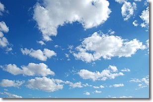
Weather Topic: What are Cumulonimbus Clouds?
Home - Education - Cloud Types - Cumulonimbus Clouds
 Next Topic: Cumulus Clouds
The final form taken by a growing cumulus cloud is the
cumulonimbus cloud, which is very tall and dense.
The tower of a cumulonimbus cloud can soar 23 km into the atmosphere, although
most commonly they stop growing at an altitude of 6 km.
Even small cumulonimbus clouds appear very large in comparison to other cloud types.
They can signal the approach of stormy weather, such as thunderstorms or blizzards.
Next Topic: Cumulus Clouds
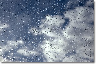
Weather Topic: What is Drizzle?
Home - Education - Precipitation - Drizzle
 Next Topic: Evaporation
Drizzle is precipitation in the form of water droplets which are
smaller than raindrops.
Drizzle is characterized by fine, gently falling droplets and typically does not
impact human habitation in a negative way. The exception to this is freezing drizzle,
a condition where drizzle freezes immediately upon reaching earth's surface.
Freezing drizzle is still less dangerous than freezing rain, but can
potentially result in hazardous road conditions.
Next Topic: Evaporation
Current conditions powered by WeatherAPI.com


