Weather Alert in Minnesota
Special Weather Statement issued May 10 at 3:25AM CDT by NWS Twin Cities/Chanhassen MN
AREAS AFFECTED: Douglas; Todd; Morrison; Mille Lacs; Kanabec; Stevens; Pope; Stearns; Benton; Sherburne; Isanti; Chisago; Lac Qui Parle; Swift; Chippewa; Kandiyohi; Meeker; Wright; Hennepin; Anoka; Ramsey; Washington; Yellow Medicine; Renville; McLeod; Sibley; Carver; Scott; Dakota; Redwood; Brown; Nicollet; Le Sueur; Rice; Goodhue; Watonwan; Blue Earth; Waseca; Steele; Martin; Faribault; Freeborn; Polk; Barron; Rusk; St. Croix; Pierce; Dunn; Pepin; Chippewa; Eau Claire
DESCRIPTION: Temperatures in the lower 70s to lower 80s this afternoon within a dry environment will cause minimum relative humidity values to drop to between 15 and 25 percent. Winds will gradually shift from northeast to southeast through this evening with sustained speeds from 8 to 15 mph, highest over western Minnesota. Gusts could reach 20 mph. Any areas with dry grasses or vegetation will be susceptible to elevated fire weather conditions. Check with the MN or WI DNR or your local county before attempting any outdoor burning.
INSTRUCTION: N/A
Want more detail? Get the Complete 7 Day and Night Detailed Forecast!
Current U.S. National Radar--Current
The Current National Weather Radar is shown below with a UTC Time (subtract 5 hours from UTC to get Eastern Time).

National Weather Forecast--Current
The Current National Weather Forecast and National Weather Map are shown below.

National Weather Forecast for Tomorrow
Tomorrow National Weather Forecast and Tomorrow National Weather Map are show below.

North America Water Vapor (Moisture)
This map shows recent moisture content over North America. Bright and colored areas show high moisture (ie, clouds); brown indicates very little moisture present; black indicates no moisture.

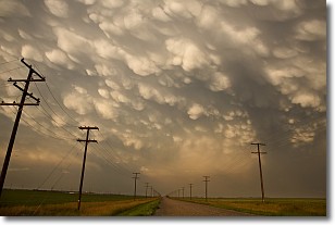
Weather Topic: What are Mammatus Clouds?
Home - Education - Cloud Types - Mammatus Clouds
 Next Topic: Nimbostratus Clouds
A mammatus cloud is a cloud with a unique feature which resembles
a web of pouches hanging along the base of the cloud.
In the United States, mammatus clouds tend to form in the warmer months, commonly
in the Midwest and eastern regions.
While they usually form at the bottom of a cumulonimbis cloud, they can also form
under altostratus, altocumulus, stratocumulus, and cirrus clouds. Mammatus clouds
warn that severe weather is close.
Next Topic: Nimbostratus Clouds
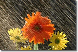
Weather Topic: What is Precipitation?
Home - Education - Precipitation - Precipitation
 Next Topic: Rain
Precipitation can refer to many different forms of water that
may fall from clouds. Precipitation occurs after a cloud has become saturated to
the point where its water particles are more dense than the air below the cloud.
In most cases, precipitation will reach the ground, but it is not uncommon for
precipitation to evaporate before it reaches the earth's surface.
When precipitation evaporates before it contacts the ground it is called Virga.
Graupel, hail, sleet, rain, drizzle, and snow are forms of precipitation, but fog
and mist are not considered precipitation because the water vapor which
constitutes them isn't dense enough to fall to the ground.
Next Topic: Rain
Current conditions powered by WeatherAPI.com


