Weather Alert in Arizona
Flash Flood Warning issued September 4 at 12:09PM MST until September 4 at 6:15PM MST by NWS Flagstaff AZ
AREAS AFFECTED: Coconino, AZ
DESCRIPTION: FFWFGZ The National Weather Service in Flagstaff has issued a * Flash Flood Warning for... The North Canyon Wash Basin downstream of the Dragon Bravo Fire scar in...Coconino County in north central Arizona...this includes the Colorado River between mile markers 17 and 21. * Until 615 PM MST /715 PM MDT/ Thursday. * At 1209 PM MST /109 PM MDT/, Doppler radar indicated thunderstorms producing heavy rain over the North Canyon Wash Basin downstream of the Dragon Bravo Fire scar. Flash flooding is ongoing or expected to begin shortly. Excessive rainfall over the burn scar will result in debris flow moving through the North Canyon Wash. The debris flow can consist of rock, mud, vegetation and other loose materials. HAZARD...Life threatening flash flooding. Thunderstorms producing flash flooding in and around the North Canyon Wash Basin downstream of the Dragon Bravo Fire scar. SOURCE...Radar indicated. IMPACT...Life threatening flash flooding of areas in and around the North Canyon Wash Basin downstream of the Dragon Bravo Fire scar. * Some locations that will experience flash flooding include... Grand Canyon National Park and Saddle Mountain Wilderness. This includes the Colorado River between mile markers 17 and 21. This includes the following recreation areas and campgrounds... House Rock Camp Site, 18 Mile Wash Camp Site, 18 Mile Ledges Camp Site, Upper North Canyon Camp Site and Lower North Canyon Camp Site. This includes the following creeks, washes and rivers... North Canyon, "18- Mile Wash", "19- Mile Canyon", Colorado River, South Canyon, House Rock Wash, Hanaa Ninadzidzahi and North Canyon Wash.
INSTRUCTION: Flash flooding is occurring or imminent downstream of the Dragon Bravo Fire scar. Severe debris flow are expected across roads and in remote canyon drainages on the Kaibab Plateau east of State Route 67. Campers and hikers should get away from creeks and move to higher ground immediately! Stay away or be swept away!
Want more detail? Get the Complete 7 Day and Night Detailed Forecast!
Current U.S. National Radar--Current
The Current National Weather Radar is shown below with a UTC Time (subtract 5 hours from UTC to get Eastern Time).

National Weather Forecast--Current
The Current National Weather Forecast and National Weather Map are shown below.

National Weather Forecast for Tomorrow
Tomorrow National Weather Forecast and Tomorrow National Weather Map are show below.

North America Water Vapor (Moisture)
This map shows recent moisture content over North America. Bright and colored areas show high moisture (ie, clouds); brown indicates very little moisture present; black indicates no moisture.

Weather Topic: What is Drizzle?
Home - Education - Precipitation - Drizzle
 Next Topic: Evaporation
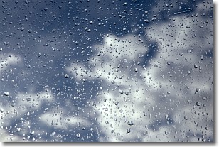
Drizzle is precipitation in the form of water droplets which are
smaller than raindrops.
Drizzle is characterized by fine, gently falling droplets and typically does not
impact human habitation in a negative way. The exception to this is freezing drizzle,
a condition where drizzle freezes immediately upon reaching earth's surface.
Freezing drizzle is still less dangerous than freezing rain, but can
potentially result in hazardous road conditions.
Next Topic: Evaporation
Weather Topic: What is Fog?
Home - Education - Cloud Types - Fog
 Next Topic: Fractus Clouds
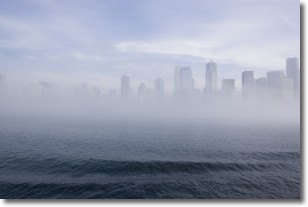
Fog is technically a type of stratus cloud, which lies along the
ground and obscures visibility.
It is usually created when humidity in the air condenses into tiny water droplets.
Because of this, some places are more prone to foggy weather, such as regions
close to a body of water.
Fog is similar to mist; both are the appearance of water droplets suspended in
the air, but fog is the term applied to the condition when visibility is less than 1 km.
Next Topic: Fractus Clouds
Current conditions powered by WeatherAPI.com


