Weather Alert in Alaska
Winter Weather Advisory issued February 26 at 3:26AM AKST until February 26 at 4:00PM AKST by NWS Juneau AK
AREAS AFFECTED: City and Borough of Sitka; Prince of Wales Island
DESCRIPTION: ...PERIODS OF SNOW SHOWERS CONTINUE THROUGH THURSDAY... .Numerous snow showers are continuing to make their way across the gulf this early morning with a more organized band of showers in the NE Gulf near Cross Sound. Additional snowfall is expected through Thursday as these showers continue to stream in from the west, gradually tapering off from north to south through the day. Snowfall accumulations will be highly variable due to hit or miss nature of showers and locally higher amounts are expected. Temperatures will continue to gradually fall through Thursday across the northern panhandle. * WHAT...Snow expected. Total snow accumulations of 4 to 7 inches. Winds gusting as high as 35 mph. * WHERE...City and Borough of Sitka and Prince of Wales Island. * WHEN...From 6 PM Wednesday to 4 PM AKST Thursday. * IMPACTS...Travel could be difficult. The hazardous conditions could impact the morning or evening commute. * ADDITIONAL DETAILS...Snow accumulations will be highly variable with localized locations having a chance of seeing accumulations a few inches higher or lower then the above range.
INSTRUCTION: Slow down and use caution while traveling. People are urged to prepare their property before the onset of winter weather. For the latest road conditions, where available, call 5 1 1 or visit 511.alaska.gov.
Want more detail? Get the Complete 7 Day and Night Detailed Forecast!
Current U.S. National Radar--Current
The Current National Weather Radar is shown below with a UTC Time (subtract 5 hours from UTC to get Eastern Time).

National Weather Forecast--Current
The Current National Weather Forecast and National Weather Map are shown below.

National Weather Forecast for Tomorrow
Tomorrow National Weather Forecast and Tomorrow National Weather Map are show below.

North America Water Vapor (Moisture)
This map shows recent moisture content over North America. Bright and colored areas show high moisture (ie, clouds); brown indicates very little moisture present; black indicates no moisture.

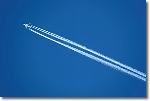
Weather Topic: What are Contrails?
Home - Education - Cloud Types - Contrails
 Next Topic: Cumulonimbus Clouds
A contrail is an artificial cloud, created by the passing of an
aircraft.
Contrails form because water vapor in the exhaust of aircraft engines is suspended
in the air under certain temperatures and humidity conditions. These contrails
are called exhaust contrails.
Another type of contrail can form due to a temporary reduction in air pressure
moving over the plane's surface, causing condensation.
These are called aerodynamic contrails.
When you can see your breath on a cold day, it is also because of condensation.
The reason contrails last longer than the condensation from your breath is
because the water in contrails freezes into ice particles.
Next Topic: Cumulonimbus Clouds
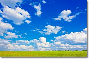
Weather Topic: What are Cumulus Clouds?
Home - Education - Cloud Types - Cumulus Clouds
 Next Topic: Drizzle
Cumulus clouds are fluffy and textured with rounded tops, and
may have flat bottoms. The border of a cumulus cloud
is clearly defined, and can have the appearance of cotton or cauliflower.
Cumulus clouds form at low altitudes (rarely above 2 km) but can grow very tall,
becoming cumulus congestus and possibly the even taller cumulonimbus clouds.
When cumulus clouds become taller, they have a greater chance of producing precipitation.
Next Topic: Drizzle
Current conditions powered by WeatherAPI.com


