Weather Alert in Kentucky
Special Weather Statement issued September 6 at 12:00AM EDT by NWS Jackson KY
AREAS AFFECTED: Knox; Harlan; Magoffin; Floyd; Breathitt; Knott; Owsley; Perry; Clay; Leslie; Letcher; Pike
DESCRIPTION: At 1200 AM EDT, Doppler radar was tracking strong thunderstorms along a line extending from Eastern to Mosley Bend to Erose. Movement was east at 35 mph. HAZARD...Wind gusts up to 40 mph and pea size hail. SOURCE...Radar indicated. IMPACT...Gusty winds could knock down tree limbs and blow around unsecured objects. Minor hail damage to vegetation is possible. Locations impacted include... Pikeville, Hazard, Hindman, Hyden, Estill, Bath, Coal Run Village, Pippa Passes, Wayland, Vicco, Buckhorn, Blackey, Elic, Meta, Big Fork, Cody, Buck, Handshoe, Brightshade, and Emmalena. THIS INCLUDES THE FOLLOWING HIGHWAYS... Hal Rogers Parkway between mile markers 29 and 59. Kentucky Highway 80 in Floyd County between mile markers 1 and 6. Kentucky Highway 80 in Knott County between mile markers 1 and 20. Kentucky Highway 80 in Perry County between mile markers 9 and 15. U.S. Highway 119 in Pike County mile marker 10 and near mile marker 13. U.S. Highway 23 in Floyd County between mile markers 1 and 3. U.S. Highway 23 in Pike County between mile markers 26 and 32.
INSTRUCTION: If outdoors, consider seeking shelter inside a building. Torrential rainfall is also occurring with these storms and may lead to localized flooding. Do not drive your vehicle through flooded roadways. A Severe Thunderstorm Watch remains in effect until 100 AM EDT for southeastern Kentucky.
Want more detail? Get the Complete 7 Day and Night Detailed Forecast!
Current U.S. National Radar--Current
The Current National Weather Radar is shown below with a UTC Time (subtract 5 hours from UTC to get Eastern Time).

National Weather Forecast--Current
The Current National Weather Forecast and National Weather Map are shown below.

National Weather Forecast for Tomorrow
Tomorrow National Weather Forecast and Tomorrow National Weather Map are show below.

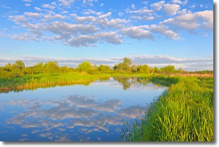
North America Water Vapor (Moisture)
This map shows recent moisture content over North America. Bright and colored areas show high moisture (ie, clouds); brown indicates very little moisture present; black indicates no moisture.

Weather Topic: What are Stratocumulus Clouds?
Home - Education - Cloud Types - Stratocumulus Clouds
 Next Topic: Stratus Clouds
Stratocumulus clouds are similar to altocumulus clouds in their
fluffy appearance, but have a slightly darker shade due to their additional mass.
A good way to distinguish the two cloud types is to hold your hand out and measure
the size of an individual cloud; if it is the size of your thumb it is generally
an altocumulus cloud, if it is the size of your hand it is generally a
stratocumulus cloud.
It is uncommon for stratocumulus clouds to produce precipitation, but if they do
it is usually a light rain or snow.
Next Topic: Stratus Clouds
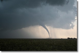
Weather Topic: What are Wall Clouds?
Home - Education - Cloud Types - Wall Clouds
 Next Topic: Altocumulus Clouds
A wall cloud forms underneath the base of a cumulonimbus cloud,
and can be a hotbed for deadly tornadoes.
Wall clouds are formed by air flowing into the cumulonimbus clouds, which can
result in the wall cloud descending from the base of the cumulonimbus cloud, or
rising fractus clouds which join to the base of the storm cloud as the wall cloud
takes shape.
Wall clouds can be very large, and in the Northern Hemisphere they generally
form at the southern edge of cumulonimbus clouds.
Next Topic: Altocumulus Clouds
Current conditions powered by WeatherAPI.com


