Weather Alert in Colorado
Hydrologic Outlook issued May 9 at 4:06PM MDT by NWS Grand Junction CO
AREAS AFFECTED: Archuleta, CO; Delta, CO; Dolores, CO; Eagle, CO; Garfield, CO; Gunnison, CO; Hinsdale, CO; La Plata, CO; Montezuma, CO; Montrose, CO; Ouray, CO; Pitkin, CO; San Juan, CO; San Miguel, CO
DESCRIPTION: ESFGJT Risk of areal flooding and elevated stream flows from rapid snowmelt ...OVERVIEW... Mid to high elevations (8500' to 10000/) along the San Juan Mountains and along the Divide through central Colorado are susceptible to enhanced runoff and elevated stream flows from rapid snowmelt. ...TEMPERATURE... High temperatures will continue to run 5 to 10 degrees above normal through the weekend, with overnight lows remaining above freezing for mid to high elevations. This warming trend carries into Monday, resulting in highs climbing 10 to 15 degrees above normal. Said departure from normal temperatures increases from south to north. ...PRECIPITATION... Isolated to scattered showers and storms developing each afternoon favor high terrain across the southwest San Juans and along the spine of the Divide. Due to warming conditions, precipitation in the form of rain is possible as high as 10,000'. Although anticipated storm totals are low, generally 0.1" to 0.2", rain-on-snow could enhance the rate of snowmelt. ...STREAMFLOW CONDITIONS AND RUNOFF FORECASTS... Streams and rivers in the area will see elevated flows of dangerously cold water over the next several days. Low-lying areas across mountainous terrain (8500' to 10,000') could see some minor inundation from snowmelt. Stay away from fast moving water and exercise caution near riverbanks and streams. Updated weather and water products and forecasts are available from the NWS Grand Junction's website at: Www.weather.gov/gjt
INSTRUCTION: N/A
Want more detail? Get the Complete 7 Day and Night Detailed Forecast!
Current U.S. National Radar--Current
The Current National Weather Radar is shown below with a UTC Time (subtract 5 hours from UTC to get Eastern Time).

National Weather Forecast--Current
The Current National Weather Forecast and National Weather Map are shown below.

National Weather Forecast for Tomorrow
Tomorrow National Weather Forecast and Tomorrow National Weather Map are show below.

North America Water Vapor (Moisture)
This map shows recent moisture content over North America. Bright and colored areas show high moisture (ie, clouds); brown indicates very little moisture present; black indicates no moisture.

Weather Topic: What is Freezing Rain?
Home - Education - Precipitation - Freezing Rain
 Next Topic: Graupel
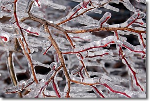
Freezing rain is a condition where precipitation which has fallen in the form of
water droplets reaches temperatures which are below freezing and freezes upon
coming into contact
with surface objects. The result of this precipitation is a glaze of ice which
can be damaging to plants and man-made structures. A severe onset of freezing
rain which results in a very thick glaze of ice is known as an ice storm.
Next Topic: Graupel
Weather Topic: What is Hail?
Home - Education - Precipitation - Hail
 Next Topic: Hole Punch Clouds
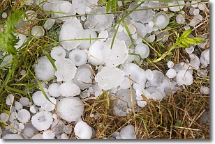
Hail is a form of precipitation which is recognized by large solid balls or
clumps of ice. Hail is created by thunderstorm clouds with strong updrafts of wind.
As the hailstones remain in the updraft, ice is deposited onto them until their
weight becomes heavy enough for them to fall to the earth's surface.
Hail storms can cause significant damage to crops, aircrafts, and man-made structures,
despite the fact that the duration is usually less than ten minutes.
Next Topic: Hole Punch Clouds
Current conditions powered by WeatherAPI.com


