Weather Alert in Alaska
Hydrologic Outlook issued August 27 at 9:45PM AKDT by NWS Fairbanks AK
AREAS AFFECTED: South Slopes Of The Central Brooks Range; South Slopes of the Western Brooks Range; Noatak Valley; Lower Kobuk Valley; Upper Kobuk Valleys; Lower Koyukuk Valley; Upper Koyukuk Valley
DESCRIPTION: ESFAFG The headwater tributaries of the Koyukuk, Kobuk and Noatak Rivers have received substantial rainfall in the last several days leading to record crests at Slate Creek near Coldfoot (30 years of record) and Dahl Creek near Kobuk (39 years of record). An additional 0.5" to 1.5" of rainfall is expected to continue in the Western and Central Brooks Range through Friday, keeping water levels on rivers high and continued standing water in poorly drained areas. The crests from the early week rainfall are making their way down the main stems of the Kobuk, Koyukuk, and Noatak Rivers through the end of the week. Expect river levels to remain high through the weekend.
INSTRUCTION: N/A
Want more detail? Get the Complete 7 Day and Night Detailed Forecast!
Current U.S. National Radar--Current
The Current National Weather Radar is shown below with a UTC Time (subtract 5 hours from UTC to get Eastern Time).

National Weather Forecast--Current
The Current National Weather Forecast and National Weather Map are shown below.

National Weather Forecast for Tomorrow
Tomorrow National Weather Forecast and Tomorrow National Weather Map are show below.

North America Water Vapor (Moisture)
This map shows recent moisture content over North America. Bright and colored areas show high moisture (ie, clouds); brown indicates very little moisture present; black indicates no moisture.

Weather Topic: What is Hail?
Home - Education - Precipitation - Hail
 Next Topic: Hole Punch Clouds
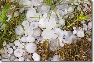
Hail is a form of precipitation which is recognized by large solid balls or
clumps of ice. Hail is created by thunderstorm clouds with strong updrafts of wind.
As the hailstones remain in the updraft, ice is deposited onto them until their
weight becomes heavy enough for them to fall to the earth's surface.
Hail storms can cause significant damage to crops, aircrafts, and man-made structures,
despite the fact that the duration is usually less than ten minutes.
Next Topic: Hole Punch Clouds
Weather Topic: What are Mammatus Clouds?
Home - Education - Cloud Types - Mammatus Clouds
 Next Topic: Nimbostratus Clouds
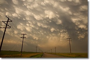
A mammatus cloud is a cloud with a unique feature which resembles
a web of pouches hanging along the base of the cloud.
In the United States, mammatus clouds tend to form in the warmer months, commonly
in the Midwest and eastern regions.
While they usually form at the bottom of a cumulonimbis cloud, they can also form
under altostratus, altocumulus, stratocumulus, and cirrus clouds. Mammatus clouds
warn that severe weather is close.
Next Topic: Nimbostratus Clouds
Current conditions powered by WeatherAPI.com


