Weather Alert in Louisiana
Special Weather Statement issued September 6 at 4:38AM CDT by NWS Jackson MS
AREAS AFFECTED: East Carroll; Madison; Franklin; Tensas; Sunflower; Leflore; Washington; Humphreys; Holmes; Issaquena; Sharkey; Yazoo; Warren
DESCRIPTION: At 436 AM CDT, Doppler radar was tracking an outflow boundary producing gusty winds along a line extending from Doddsville to near Rolling Fork to near Baskin. Movement was east at 35 mph. HAZARD...Wind gusts up to 40 mph. SOURCE...Radar indicated. IMPACT...Gusty winds could knock down tree limbs and blow around unsecured objects. Strong thunderstorms will be near... Moorhead, Sunflower, Inverness, Isola, Bakers, Onward, Waverly, Omega, Blaine, and Tendal around 440 AM CDT. Tallulah, Belzoni, Schlater, Louise, Mansford, and Midnight around 445 AM CDT. Itta Bena, Silver City, Eagle Bend, Valley Park, and Swiftown around 450 AM CDT. Morgan City and Quito around 455 AM CDT. Greenwood and Yazoo City around 500 AM CDT. Sidon, Satartia, Tinsley, and Afton around 505 AM CDT. Other locations impacted by these storms include Richmond.
INSTRUCTION: If outdoors, consider seeking shelter inside a building. High winds can bring down trees and large limbs resulting in serious injury or property damage. Exercise extreme caution when outdoors during such strong winds...and be especially aware of older trees.
Want more detail? Get the Complete 7 Day and Night Detailed Forecast!
Current U.S. National Radar--Current
The Current National Weather Radar is shown below with a UTC Time (subtract 5 hours from UTC to get Eastern Time).

National Weather Forecast--Current
The Current National Weather Forecast and National Weather Map are shown below.

National Weather Forecast for Tomorrow
Tomorrow National Weather Forecast and Tomorrow National Weather Map are show below.

North America Water Vapor (Moisture)
This map shows recent moisture content over North America. Bright and colored areas show high moisture (ie, clouds); brown indicates very little moisture present; black indicates no moisture.

Weather Topic: What are Cirrus Clouds?
Home - Education - Cloud Types - Cirrus Clouds
 Next Topic: Condensation
Cirrus clouds are high-level clouds that occur above 20,000 feet
and are composed mainly of ice crystals.
They are thin and wispy in appearance.
What do they indicate?
They are often the first sign of an approaching storm.
Next Topic: Condensation
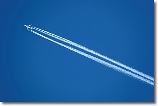
Weather Topic: What are Contrails?
Home - Education - Cloud Types - Contrails
 Next Topic: Cumulonimbus Clouds
A contrail is an artificial cloud, created by the passing of an
aircraft.
Contrails form because water vapor in the exhaust of aircraft engines is suspended
in the air under certain temperatures and humidity conditions. These contrails
are called exhaust contrails.
Another type of contrail can form due to a temporary reduction in air pressure
moving over the plane's surface, causing condensation.
These are called aerodynamic contrails.
When you can see your breath on a cold day, it is also because of condensation.
The reason contrails last longer than the condensation from your breath is
because the water in contrails freezes into ice particles.
Next Topic: Cumulonimbus Clouds
Current conditions powered by WeatherAPI.com


