Weather Alert in Ohio
Special Weather Statement issued February 6 at 8:29PM EST by NWS Cleveland OH
AREAS AFFECTED: Stark; Mahoning; Holmes
DESCRIPTION: At 827 PM EST, radar indicated snow showers along a line extending from near Vienna Center to near Alliance to near Shreve, moving southeast at 40 mph. HAZARDS INCLUDE... Winds to 40 mph... Visibility dropping to less than one half mile... Up to 1 inch of quick snow accumulation... Motorists traveling on Interstate 77 and 80 should prepare for deteriorating conditions. Locations impacted include... Canton, Youngstown, Salem, Columbiana, Millersburg, Boardman, Massillon, Green, Alliance, North Canton, Louisville, Campbell, Canfield, Berlin, Sebring, Walnut Creek, Minerva, Hartville, Loudonville, and Brewster. Use extra caution if you must travel. Rapid changes in visibility and potentially slick roads may lead to accidents.
INSTRUCTION: N/A
Want more detail? Get the Complete 7 Day and Night Detailed Forecast!
Current U.S. National Radar--Current
The Current National Weather Radar is shown below with a UTC Time (subtract 5 hours from UTC to get Eastern Time).

National Weather Forecast--Current
The Current National Weather Forecast and National Weather Map are shown below.

National Weather Forecast for Tomorrow
Tomorrow National Weather Forecast and Tomorrow National Weather Map are show below.

North America Water Vapor (Moisture)
This map shows recent moisture content over North America. Bright and colored areas show high moisture (ie, clouds); brown indicates very little moisture present; black indicates no moisture.

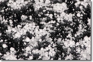
Weather Topic: What is Graupel?
Home - Education - Precipitation - Graupel
 Next Topic: Hail
Graupel is a form of precipitation that is created by atmospheric conditions
which cause supercooled water droplets to contact snow crystals and freeze to
their surface.
Sometimes known as soft hail or snow pellets, graupel is delicate and easily
destroyed by touch. Whereas hail usually falls during severe weather, graupel
doesn't require such conditions to form, and can form in mild precipitation
similar to situations which produce snowfall.
Next Topic: Hail
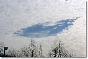
Weather Topic: What are Hole Punch Clouds?
Home - Education - Cloud Types - Hole Punch Clouds
 Next Topic: Mammatus Clouds
A hole punch cloud is an unusual occurrence when a disk-shaped
hole appears in a cirrostratus, cirrocumulus, or altocumulus cloud.
When part of the cloud forms ice crystals, water droplets in the surrounding area
of the cloud evaporate. The effect of this process produces a large elliptical
gap in the cloud. The hole punch cloud formation is rare, but it is not specific
to any geographic area.
Other names which have been used to describe this phenomena include fallstreak hole,
skypunch, and cloud hole.
Next Topic: Mammatus Clouds
Current conditions powered by WeatherAPI.com


